1960s Maps of Big Flat, Arkansas
Explore 3 historic maps of Big Flat from the 1960s. These maps offer a rare glimpse into what life looked like during the 1960s — showing old roads, neighborhoods, homes, and landmarks that have changed or disappeared over time.
Whether you're researching your family's past, planning a metal detecting trip, or studying how Big Flat's landscape evolved across the 1960s, these high-resolution maps are a powerful tool for exploring the history of this region.
- Focus on a specific era: All maps on this page are from the 1960s, giving you a focused view of this time period.
- See what’s changed: Compare century-old streets, trails, and buildings to today's modern landscape using overlays and satellite layers.
- Research with precision: Use these maps for genealogy, historical research, land use analysis, or educational projects.
- View, download, or print: Maps are fully viewable online in high resolution, and can be downloaded or printed for your own records.
Start exploring Big Flat's history through authentic maps from the 1960s. This is your window into the past.
Big Flat, AR maps
(3)- 1964 Map of Russellville
 1964 Russellville1964 Print · USGSMid-century Central Arkansas is defined here by the river-valley towns and the surrounding mountain ranges before the full expansion of the interstate system. Genealogists and historians can trace rail-town development along the Missouri Pacific Railroad and locate landmarks like Arkansas Polytechnic College or Petit Jean State Park.
 - 1964 Map of Harrison
 1964 Harrison1964 Print · USGSThe Ozark and Boston Mountains of Arkansas and Missouri are captured here in the mid-sixties, showing the rugged highlands before extensive modern development. Genealogists and historians can trace family-named peaks like Gaither Mountain and follow the St Louis-San Francisco RR through Monett and Purdy.
 - 1966 Map of Big Flat, 1967 Print
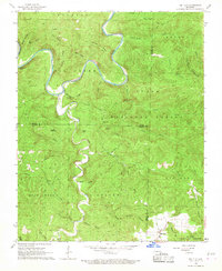 1966 Big Flat1967 Print · USGSThe Buffalo River highlands in the mid-sixties show a landscape of deep hollows and isolated mountain knobs. Genealogists and local historians can trace the roads around Big Flat, locate the local Cem, and explore the terrain near Suggs Mountain and Almus Knob.3 unique versions available
End of results
Showing maps 1-3 of 3
Top cities near Big Flat
- Marshall historical maps
- Norfork historical maps
- Salesville historical maps
- Leslie historical maps
- Fifty-Six historical maps
Frequently asked questions
- What are the different types of historical maps available for Big Flat?
- What is the oldest map of Big Flat?
- Where can I purchase historical maps of Big Flat for my home or office?
- Where can I download high-res historical maps of Big Flat?
- Are there historical topographic maps available for Big Flat?
- Is there historical aerial imagery available for Big Flat?
- Where are historical maps of Big Flat sourced from?