1970s Maps of Carmel, Arkansas
Explore 2 historic maps of Carmel from the 1970s. These maps offer a rare glimpse into what life looked like during the 1970s — showing old roads, neighborhoods, homes, and landmarks that have changed or disappeared over time.
Whether you're researching your family's past, planning a metal detecting trip, or studying how Carmel's landscape evolved across the 1970s, these high-resolution maps are a powerful tool for exploring the history of this region.
- Focus on a specific era: All maps on this page are from the 1970s, giving you a focused view of this time period.
- See what’s changed: Compare century-old streets, trails, and buildings to today's modern landscape using overlays and satellite layers.
- Research with precision: Use these maps for genealogy, historical research, land use analysis, or educational projects.
- View, download, or print: Maps are fully viewable online in high resolution, and can be downloaded or printed for your own records.
Start exploring Carmel's history through authentic maps from the 1970s. This is your window into the past.
Carmel, AR maps
(2)- 1973 Map of Warren, 1975 Print
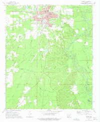 1973 Warren1975 Print · USGSWarren was a bustling Bradley County rail and timber center in the early seventies, caught here just as the river-and-rail economy transitioned. Genealogists and local historians can trace family roots through sites like Oakland Cemetery, St James Church, and the outlying settlement of Carmel.2 unique versions available
 - 1978 Map of Warren
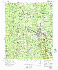 1978 Warren1978 Print · USGSBradley County life in the late 1970s centered on the hub of Warren and its network of rural churches and family farms. Researchers can trace local lineage through sites like Parnell Cem, Moseley Chapel, and the community of Farmville.
End of results
Showing maps 1-2 of 2
Top cities near Carmel
- Warren historical maps
- Hermitage historical maps
- Wilmar historical maps
- Fountain Hill historical maps
- Banks historical maps
Frequently asked questions
- What are the different types of historical maps available for Carmel?
- What is the oldest map of Carmel?
- Where can I purchase historical maps of Carmel for my home or office?
- Where can I download high-res historical maps of Carmel?
- Are there historical topographic maps available for Carmel?
- Is there historical aerial imagery available for Carmel?
- Where are historical maps of Carmel sourced from?