1960s Maps of Carroll County, Arkansas
Explore 5 historic maps of Carroll County from the 1960s. These maps offer a rare glimpse into what life looked like during the 1960s — showing old roads, neighborhoods, homes, and landmarks that have changed or disappeared over time.
Whether you're researching your family's past, planning a metal detecting trip, or studying how Carroll County's landscape evolved across the 1960s, these high-resolution maps are a powerful tool for exploring the history of this region.
- Focus on a specific era: All maps on this page are from the 1960s, giving you a focused view of this time period.
- See what’s changed: Compare century-old streets, trails, and buildings to today's modern landscape using overlays and satellite layers.
- Research with precision: Use these maps for genealogy, historical research, land use analysis, or educational projects.
- View, download, or print: Maps are fully viewable online in high resolution, and can be downloaded or printed for your own records.
Start exploring Carroll County's history through authentic maps from the 1960s. This is your window into the past.
Carroll County, AR maps
(5)- 1964 Map of Harrison
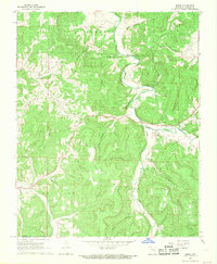
 1964 Harrison1964 Print · USGSThe Ozark and Boston Mountains of Arkansas and Missouri are captured here in the mid-sixties, showing the rugged highlands before extensive modern development. Genealogists and historians can trace family-named peaks like Gaither Mountain and follow the St Louis-San Francisco RR through Monett and Purdy.
 - 1967 Map of Ponca, 1968 Print
 1967 Ponca1968 Print · USGSThe Buffalo River corridor in the late sixties shows a landscape of deep hollows and high Ozark ridges. Researchers can trace rural genealogy through landmarks like Mountain Springs Cem and Plumlee Ch or locate the site of the Compton Lookout Tower.3 unique versions available
 - 1968 Map of Osage NE, 1969 Print
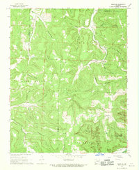
 1968 Osage NE1969 Print · USGSIn the late sixties, this Carroll County uplands region around Delmar maintained its traditional character amidst a rugged landscape of hollows and bluffs. Researchers can find generational landmarks like Possum Trot Ch, Hilltop Cem, and the high peak of Needle Eye Mountain.2 unique versions available
 - 1968 Map of Osage, 1969 Print
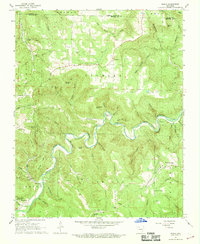
 1968 Osage1969 Print · USGSCarroll County in the late sixties remains a landscape of deep hollows and high ridges centered on the Osage Creek valley. Genealogists and local historians can trace family locations near Rudd, the Gobbler Ch, and numerous burial sites including Bobo Cem.2 unique versions available
 - 1968 Map of Osage SW, 1969 Print
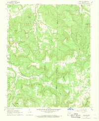
 1968 Osage SW1969 Print · USGSNewton County in the late 1960s remains a landscape of deep hollows and high ridges at the Buffalo River's edge. Researchers can trace the rural communities of George, Dinsmore, and Stoverville alongside family landmarks like Elkhorn Church.4 unique versions available
End of results
Showing maps 1-5 of 5
Top cities of Carroll County
- Berryville historical maps
- Green Forest historical maps
- Eureka Springs historical maps
- Hough historical maps
- Oak Grove historical maps
- Beaver historical maps
See more
Frequently asked questions
- What are the different types of historical maps available for Carroll County?
- What is the oldest map of Carroll County?
- Where can I purchase historical maps of Carroll County for my home or office?
- Where can I download high-res historical maps of Carroll County?
- Are there historical topographic maps available for Carroll County?
- Is there historical aerial imagery available for Carroll County?
- Where are historical maps of Carroll County sourced from?