1970s Maps of Gurdon, Arkansas
Explore 2 historic maps of Gurdon from the 1970s. These maps offer a rare glimpse into what life looked like during the 1970s — showing old roads, neighborhoods, homes, and landmarks that have changed or disappeared over time.
Whether you're researching your family's past, planning a metal detecting trip, or studying how Gurdon's landscape evolved across the 1970s, these high-resolution maps are a powerful tool for exploring the history of this region.
- Focus on a specific era: All maps on this page are from the 1970s, giving you a focused view of this time period.
- See what’s changed: Compare century-old streets, trails, and buildings to today's modern landscape using overlays and satellite layers.
- Research with precision: Use these maps for genealogy, historical research, land use analysis, or educational projects.
- View, download, or print: Maps are fully viewable online in high resolution, and can be downloaded or printed for your own records.
Start exploring Gurdon's history through authentic maps from the 1970s. This is your window into the past.
Gurdon, AR maps
(2)- 1970 Map of Gurdon, 1972 Print
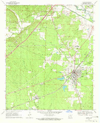 1970 Gurdon1972 Print · USGSSouthwest Arkansas industry and rail life are on display here in the early seventies, centered on the growing hub of Gurdon. Local historians can trace the Missouri Pacific line through Beirne, locate the Gurdon Municipal Airfield, and find family sites like Greenville Cem or New Casey Ch.
 - 1972 Map of Gurdon, 1973 Print
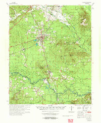 1972 Gurdon1973 Print · USGSSouthern Arkansas in the early seventies reveals a landscape of river-bottom sloughs, timbered ridges, and deep-seated rural communities. Genealogists and local researchers can trace family landmarks like Harts Chapel Cem, Whelen Springs, and the Lewis Randolph Grave.
End of results
Showing maps 1-2 of 2
Top cities near Gurdon
- Arkadelphia historical maps
- Arkadelphia historical maps
- Prescott historical maps
- Chidester historical maps
- Gum Springs historical maps
- Okolona historical maps
See more
Frequently asked questions
- What are the different types of historical maps available for Gurdon?
- What is the oldest map of Gurdon?
- Where can I purchase historical maps of Gurdon for my home or office?
- Where can I download high-res historical maps of Gurdon?
- Are there historical topographic maps available for Gurdon?
- Is there historical aerial imagery available for Gurdon?
- Where are historical maps of Gurdon sourced from?