1900s (20th Century) Maps of Concord, Arkansas
Explore 6 historic maps of Concord from the 1900s (20th Century). These maps offer a rare glimpse into what life looked like during the 1900s — showing old roads, neighborhoods, homes, and landmarks that have changed or disappeared over time.
Whether you're researching your family's past, planning a metal detecting trip, or studying how Concord's landscape evolved across the 1900s, these high-resolution maps are a powerful tool for exploring the history of this region.
- Focus on a specific era: All maps on this page are from the 1900s, giving you a focused view of this time period.
- See what’s changed: Compare century-old streets, trails, and buildings to today's modern landscape using overlays and satellite layers.
- Research with precision: Use these maps for genealogy, historical research, land use analysis, or educational projects.
- View, download, or print: Maps are fully viewable online in high resolution, and can be downloaded or printed for your own records.
Start exploring Concord's history through authentic maps from the 1900s. This is your window into the past.
Concord, AR maps
(6)- 1942 Map of Almond, 1945 Print
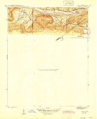 1942 Almond1945 Print · USGSThe river-and-rail corridor along the White River defines this 1940s landscape where Independence and Cleburne Counties meet. Genealogists and historians can trace old transit points like Earnhearts Ferry and the Old Cherokee Line boundary.3 unique versions available
 - 1953 Map of Memphis, 1966 Print
 1953 Memphis1966 Print · USGSEastern Arkansas and the Memphis riverfront are shown here during the mid-century period of regional growth and river management. Local historians can trace the paths of the Chicago Rock Island & Pacific RR through Forrest City or locate river landmarks like President's Island.3 unique versions available
 - 1956 Map of Memphis
 1956 Memphis1956 Print · USGSThe Mississippi Delta and the bluffs of West Tennessee meet in the mid-fifties, showing a landscape defined by massive river systems and rail hubs. Researchers can trace the path of Crowleys Ridge or locate vanished river landings near Centennial Island and Island No 35.
 - 1973 Map of Concord, 1975 Print
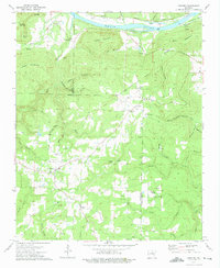 1973 Concord1975 Print · USGSNorth central Arkansas highlands meet the river valley in the 1970s, as small mountain communities like Concord and Almond grew near the Indian Treaty Boundary. Genealogists can locate family landmarks such as Bellmore Cem and Banner Ch tucked between the ridges and river sloughs.
 - 1973 Map of Drasco, 1975 Print
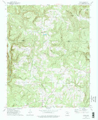 1973 Drasco1975 Print · USGSThe borderlands of Cleburne and Stone counties appear here in the early 1970s, showing a landscape of family-named ridges and isolated hollows. You can trace early cemetery locations like Macedonia Cem or find the historic Treaty Boundary near Schoolhouse Hill.2 unique versions available
 - 1986 Map of Batesville
 1986 Batesville1986 Print · USGSNorth-central Arkansas in the mid-eighties shows a landscape of river-bend towns and Ozark foothills during a period of steady growth. You can trace family roots through numerous upland sites like Hickory Valley School, Sandtown Hill Cem, and the riverfront at Oil Trough.2 unique versions available
End of results
Showing maps 1-6 of 6
Top cities near Concord
- Batesville historical maps
- Heber Springs historical maps
- Southside historical maps
- Mountain View historical maps
- Cushman historical maps
- Pleasant Plains historical maps
Frequently asked questions
- What are the different types of historical maps available for Concord?
- What is the oldest map of Concord?
- Where can I purchase historical maps of Concord for my home or office?
- Where can I download high-res historical maps of Concord?
- Are there historical topographic maps available for Concord?
- Is there historical aerial imagery available for Concord?
- Where are historical maps of Concord sourced from?