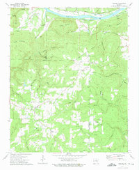
1973 Map of Concord
USGS Topo · Published 1975About this map
White River navigation and mountain ridge lines define this portion of the Ozark foothills during the early 1970s. The landscape is marked by the Indian Treaty Boundary cutting across the terrain, separating the northern hills from the developing settlements to the south. Along the river, Earnheart Island and Foushee Island sit near the Lock and Dam No 2 (Inactive), while the Missouri Pacific railroad follows the northern bank.
Find a feature on this map
63 named features on this map. Tap any name to fly to it.
Don’t see what you’re looking for? This feature index may not catch every label — zoom into the map to look around manually.
Map Details
Editions of this 1973 Concord Map
This is the sole edition of this map. No revisions or reprints were ever made.
Other maps of this area

1890 · Batesville
USGS Topo · 1:125,000

1891 · Batesville
USGS Topo · 1:125,000

1942 · Bethesda
USGS Topo · 1:24,000

1942 · Jamestown
USGS Topo · 1:31,680

1942 · Almond
USGS Topo · 1:31,680

1942 · Batesville
USGS Topo · 1:31,680

1943 · Batesville
USGS Topo · 1:24,000

1953 · Memphis
USGS Topo · 1:250,000

1956 · Memphis
USGS Topo · 1:250,000

1965 · Pleasant Plains
USGS Topo · 1:24,000