
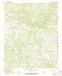
1965 Map of Pleasant Plains
USGS Topo · Published 1966About this map
Pleasant Plains serves as the primary community in this mid-1960s study of the border between Independence and White counties. The landscape is defined by the winding course of Salado Creek and its many tributaries, such as Fourteenmile Creek and Tenmile Creek. The area’s spiritual and communal life is anchored by several rural churches, including New Bethel Ch, Union Grove Ch, and Flippo Chapel. Youth and community organization are represented by Camp Tahkodah and Camp Crossed Arrows, both established near the northern waters. Industrial activity is visible in the form of a Shale Pit and several gravel extractions. The map also reveals the rural settlement patterns of the era, from the small hub at Roosevelt to the various farmsteads and cemeteries like Old Union Cem that dot the countryside.
Find a feature on this map
35 named features on this map. Tap any name to fly to it.
Don’t see what you’re looking for? This feature index may not catch every label — zoom into the map to look around manually.
Map Details
Editions of this 1965 Pleasant Plains Map
2 editions found
Other maps of this area

1890 · Batesville
USGS Topo · 1:125,000

1891 · Batesville
USGS Topo · 1:125,000

1935 · Bald Knob
USGS Topo · 1:62,500

1942 · Jamestown
USGS Topo · 1:31,680

1942 · Almond
USGS Topo · 1:31,680

1942 · Salado
USGS Topo · 1:31,680

1953 · Memphis
USGS Topo · 1:250,000

1956 · Memphis
USGS Topo · 1:250,000

1962 · Pangburn
USGS Topo · 1:24,000
1965 · Salado
USGS Topo · 1:24,000