1930s Maps of Jennette, Arkansas
Explore 1 historic maps of Jennette from the 1930s. These maps offer a rare glimpse into what life looked like during the 1930s — showing old roads, neighborhoods, homes, and landmarks that have changed or disappeared over time.
Whether you're researching your family's past, planning a metal detecting trip, or studying how Jennette's landscape evolved across the 1930s, these high-resolution maps are a powerful tool for exploring the history of this region.
- Focus on a specific era: All maps on this page are from the 1930s, giving you a focused view of this time period.
- See what’s changed: Compare century-old streets, trails, and buildings to today's modern landscape using overlays and satellite layers.
- Research with precision: Use these maps for genealogy, historical research, land use analysis, or educational projects.
- View, download, or print: Maps are fully viewable online in high resolution, and can be downloaded or printed for your own records.
Start exploring Jennette's history through authentic maps from the 1930s. This is your window into the past.
Jennette, AR maps
(1)- 1939 Map of Edmondson, 1942 Print
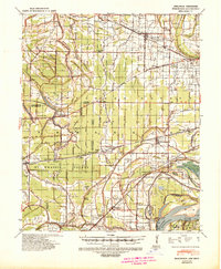 1939 Edmondson1942 Print · USGSCrittenden and St. Francis Counties are shown in the late thirties as a landscape of rail-connected farming towns and bayous. Genealogists can locate family landmarks like Garrett Cem, Macedonia Ch, and the combined Bellmeade Sch & Ch.
End of results
Showing maps 1-1 of 1
Top cities near Jennette
- Memphis historical maps
- West Memphis historical maps
- Marion historical maps
- Earle historical maps
- Hughes historical maps
- Parkin historical maps
See more
Top neighborhoods of Jennette
Frequently asked questions
- What are the different types of historical maps available for Jennette?
- What is the oldest map of Jennette?
- Where can I purchase historical maps of Jennette for my home or office?
- Where can I download high-res historical maps of Jennette?
- Are there historical topographic maps available for Jennette?
- Is there historical aerial imagery available for Jennette?
- Where are historical maps of Jennette sourced from?