1970s Maps of Marion, Arkansas
Explore 3 historic maps of Marion from the 1970s. These maps offer a rare glimpse into what life looked like during the 1970s — showing old roads, neighborhoods, homes, and landmarks that have changed or disappeared over time.
Whether you're researching your family's past, planning a metal detecting trip, or studying how Marion's landscape evolved across the 1970s, these high-resolution maps are a powerful tool for exploring the history of this region.
- Focus on a specific era: All maps on this page are from the 1970s, giving you a focused view of this time period.
- See what’s changed: Compare century-old streets, trails, and buildings to today's modern landscape using overlays and satellite layers.
- Research with precision: Use these maps for genealogy, historical research, land use analysis, or educational projects.
- View, download, or print: Maps are fully viewable online in high resolution, and can be downloaded or printed for your own records.
Start exploring Marion's history through authentic maps from the 1970s. This is your window into the past.
Marion, AR maps
(3)- 1970 Map of Jericho, 1974 Print
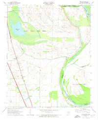 1970 Jericho1974 Print · USGSCrittenden County, Arkansas, and the Mississippi riverfront appear in the 1970s as a managed landscape of agriculture and wildlife preservation. Family historians can trace small-town life in Jericho and Clarkedale, or locate rural markers like Malone Cem and New Mt Zion Ch.2 unique versions available
 - 1975 Map of Jericho
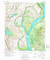 1975 Jericho1975 Print · USGSThe Mississippi River meanders through the Arkansas and Tennessee borderlands in the mid-seventies, documenting a landscape shaped by massive river bars and drainage ditches. Trace family sites at Jericho, Frenchmans Bayou, and small country landmarks like St Paul Cem or Paradise Ch.
 - 1975 Map of Edmondson NE, 1976 Print
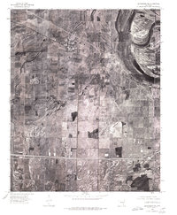 1975 Edmondson NE1976 Print · USGSCrittenden County's agricultural heartland is documented in the mid-1970s through this detailed aerial survey. Genealogists and local historians can trace exact farmstead locations and rural crossroads settlements like Crawfordsville, Vincent, and Lehi.
End of results
Showing maps 1-3 of 3
Top cities near Marion
- Memphis historical maps
- Southaven historical maps
- West Memphis historical maps
- Turrell historical maps
- Crawfordsville historical maps
- Clarkedale historical maps
See more
Top neighborhoods of Marion
Frequently asked questions
- What are the different types of historical maps available for Marion?
- What is the oldest map of Marion?
- Where can I purchase historical maps of Marion for my home or office?
- Where can I download high-res historical maps of Marion?
- Are there historical topographic maps available for Marion?
- Is there historical aerial imagery available for Marion?
- Where are historical maps of Marion sourced from?