1940s Maps of Cross County, Arkansas
Explore 4 historic maps of Cross County from the 1940s. These maps offer a rare glimpse into what life looked like during the 1940s — showing old roads, neighborhoods, homes, and landmarks that have changed or disappeared over time.
Whether you're researching your family's past, planning a metal detecting trip, or studying how Cross County's landscape evolved across the 1940s, these high-resolution maps are a powerful tool for exploring the history of this region.
- Focus on a specific era: All maps on this page are from the 1940s, giving you a focused view of this time period.
- See what’s changed: Compare century-old streets, trails, and buildings to today's modern landscape using overlays and satellite layers.
- Research with precision: Use these maps for genealogy, historical research, land use analysis, or educational projects.
- View, download, or print: Maps are fully viewable online in high resolution, and can be downloaded or printed for your own records.
Start exploring Cross County's history through authentic maps from the 1940s. This is your window into the past.
Cross County, AR maps
(4)- 1940 Map of Deckerville, 1942 Print
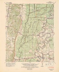
 1940 Deckerville1942 Print · USGSCrittenden and Poinsett counties are shown here as the local river-and-rail economy matured before the war. Genealogists can trace family landmarks like the King Solomon Sch & Cem, Booker Sch, and New Bethlehem Ch & Cem.
 - 1940 Map of Princedale, 1942 Print
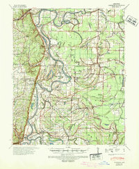
 1940 Princedale1942 Print · USGSEastern Arkansas at the cusp of World War II is mapped here as a land of managed floodways and emerging rail towns. Genealogists can trace family footprints at Hare Farm Sch, Sharps Chapel, and along the banks of the St Francis River.2 unique versions available
 - 1940 Map of Whitmore, 1942 Print
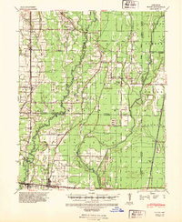
 1940 Whitmore1942 Print · USGSSt. Francis County in the early 1940s shows a complex river-and-rail landscape shaped by the meanders of the St Francis River. Researchers can trace old family settlements and rural institutions like Wittsburg, the Church of Bethlehem, and Walters Cem.2 unique versions available
 - 1940 Map of Tilton, 1947 Print
 1940 Tilton1947 Print · USGSEastern Arkansas at the start of the 1940s is captured here as a landscape of river-fed bottoms and thriving rail-side towns. Genealogists and local historians can trace family roots through the numerous rural landmarks like Fakes Chapel & Cem, Pumpkin Bend Cem, and Weldon Sch.2 unique versions available
End of results
Showing maps 1-4 of 4
Top cities of Cross County
- Wynne historical maps
- Parkin historical maps
- Cherry Valley historical maps
- Hickory Ridge historical maps
Frequently asked questions
- What are the different types of historical maps available for Cross County?
- What is the oldest map of Cross County?
- Where can I purchase historical maps of Cross County for my home or office?
- Where can I download high-res historical maps of Cross County?
- Are there historical topographic maps available for Cross County?
- Is there historical aerial imagery available for Cross County?
- Where are historical maps of Cross County sourced from?