1900s (20th Century) Maps of Dumas, Arkansas
Explore 10 historic maps of Dumas from the 1900s (20th Century). These maps offer a rare glimpse into what life looked like during the 1900s — showing old roads, neighborhoods, homes, and landmarks that have changed or disappeared over time.
Whether you're researching your family's past, planning a metal detecting trip, or studying how Dumas's landscape evolved across the 1900s, these high-resolution maps are a powerful tool for exploring the history of this region.
- Focus on a specific era: All maps on this page are from the 1900s, giving you a focused view of this time period.
- See what’s changed: Compare century-old streets, trails, and buildings to today's modern landscape using overlays and satellite layers.
- Research with precision: Use these maps for genealogy, historical research, land use analysis, or educational projects.
- View, download, or print: Maps are fully viewable online in high resolution, and can be downloaded or printed for your own records.
Start exploring Dumas's history through authentic maps from the 1900s. This is your window into the past.
Dumas, AR maps
(10)- 1935 Map of Rotan, 1942 Print
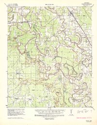 1935 Rotan1942 Print · USGSThe Arkansas delta comes to life in the mid-1930s as a complex network of timber camps, bayous, and rail towns. Genealogists can trace the rural communities of Rotan and Gould, or locate family sites at Thomas Cem and New Bethel Ch.2 unique versions available
 - 1935 Map of Red Fork, 1943 Print
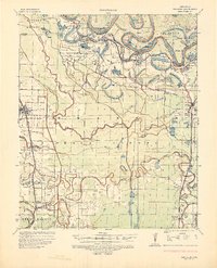 1935 Red Fork1943 Print · USGSDesha County's riverfront and rail lines are captured here in the mid-1930s, showing a landscape shaped by the Arkansas River. Researchers can trace the Missouri Pacific corridor through Dumas or locate the Indian Mound near Red Fork.3 unique versions available
 - 1953 Map of Greenwood, 1966 Print
 1953 Greenwood1966 Print · USGSThe Mississippi Delta in the mid-fifties is captured here as a thriving network of river towns, railroads, and oxbow lakes. Researchers can trace the legacy of the Illinois Central Railroad and locate landmarks like the State Penal Farm and Greenville Air Force Base.5 unique versions available
 - 1956 Map of Greenwood
 1956 Greenwood1956 Print · USGSThe Mississippi Delta in the mid-fifties is captured here during a period of significant military and agricultural activity. Researchers can trace the rail lines of the Illinois Central RR, find the Greenville Air Force Base, or locate the State Penal Farm.
 - 1964 Map of Gould, 1965 Print
 1964 Gould1965 Print · USGSSoutheast Arkansas in the mid-sixties reveals a landscape of delta farming shaped by bayous and new irrigation canals. Genealogists and local historians can trace rural communities through landmarks like Wells Bayou Sch, Thomas Chapel, and the Missouri Pacific line through Gould.2 unique versions available
 - 1968 Map of Rotan
 1968 Rotan1968 Print · USGSThe Arkansas Delta of the late sixties comes alive through its network of bayous and rural crossroads. Genealogists can trace family roots through landmarks like Smyrna Ch, the Wells Bayou School, and Dark Corners Church.
 - 1969 Map of Winchester, 1971 Print
 1969 Winchester1971 Print · USGSThe Arkansas Delta comes to life in the late sixties as aquaculture and rail lines shape the landscape near the Desha and Drew county line. Trace family roots and local history at Winchester, Pickens, and numerous rural burial grounds like Jefferson Cem.2 unique versions available
 - 1969 Map of Dumas, 1971 Print
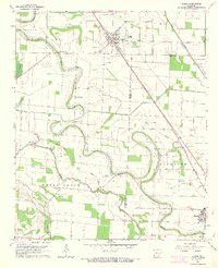
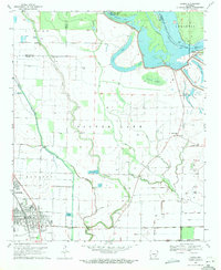 1969 Dumas1971 Print · USGSThe Arkansas Delta comes to life in the late 1960s as a landscape of river-bend lakes and rail-side towns. Genealogists can locate family landmarks like Havis Chapel, the Pendleton Ferry crossing, and the rural Leach Cem near the river's edge.2 unique versions available
 - 1971 Map of Dumas
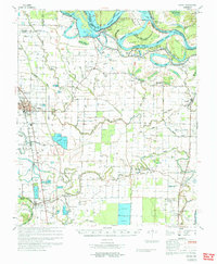 1971 Dumas1971 Print · USGSSoutheast Arkansas in the early seventies shows a landscape defined by the shifting Arkansas River and a deep-rooted railroad economy. Genealogists and historians can trace numerous rural congregations and family burial sites, including Claiborne Chapel, Jerusalem Cem, and the Memorial Cem near Rohwer.
 - 1986 Map of Dumas
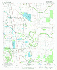
 1986 Dumas1986 Print · USGSSoutheast Arkansas in the mid-eighties shows a landscape defined by the winding Mississippi River and the Missouri Pacific Railroad corridor. Genealogists can trace family roots through river towns like Arkansas City and the rail-junction history of McGehee.2 unique versions available
End of results
Showing maps 1-10 of 10
Top cities near Dumas
- McGehee historical maps
- Gould historical maps
- Grady historical maps
- Mitchellville historical maps
- Watson historical maps
- Tillar historical maps
See more
Frequently asked questions
- What are the different types of historical maps available for Dumas?
- What is the oldest map of Dumas?
- Where can I purchase historical maps of Dumas for my home or office?
- Where can I download high-res historical maps of Dumas?
- Are there historical topographic maps available for Dumas?
- Is there historical aerial imagery available for Dumas?
- Where are historical maps of Dumas sourced from?