1990s Maps of Vilonia, Arkansas
Explore 3 historic maps of Vilonia from the 1990s. These maps offer a rare glimpse into what life looked like during the 1990s — showing old roads, neighborhoods, homes, and landmarks that have changed or disappeared over time.
Whether you're researching your family's past, planning a metal detecting trip, or studying how Vilonia's landscape evolved across the 1990s, these high-resolution maps are a powerful tool for exploring the history of this region.
- Focus on a specific era: All maps on this page are from the 1990s, giving you a focused view of this time period.
- See what’s changed: Compare century-old streets, trails, and buildings to today's modern landscape using overlays and satellite layers.
- Research with precision: Use these maps for genealogy, historical research, land use analysis, or educational projects.
- View, download, or print: Maps are fully viewable online in high resolution, and can be downloaded or printed for your own records.
Start exploring Vilonia's history through authentic maps from the 1990s. This is your window into the past.
Vilonia, AR maps
(3)- 1992 Map of Russellville, 1993 Print
 1992 Russellville1993 Print · USGSCentral Arkansas in the early nineties shows a landscape defined by the Arkansas River valley and the surrounding national forests. Trace the development of river towns like Russellville and Dardanelle alongside landmarks such as Lake Dardanelle and Magazine Mtn.
 - 1994 Map of Hamlet
 1994 Hamlet1994 Print · USGSFaulkner County's rural communities and church-centered settlements are captured here in the mid-1990s. Researchers can trace family history through sites like New Liberty Cem, Old Liberty Ch, and the crossroads at Hamlet and Saltillo.
 - 1994 Map of Vilonia
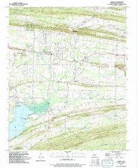
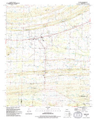 1994 Vilonia1994 Print · USGSThe Vilonia area in the mid-nineties shows a rural Arkansas landscape transitioning between the Faulkner and Pulaski county lines. Trace local family roots and early community centers at Otto Community Ch, Cypress Valley Cem, and the Lester Flatt Memorial Park.
End of results
Showing maps 1-3 of 3
Top cities near Vilonia
- North Little Rock historical maps
- Conway historical maps
- Jacksonville historical maps
- Cabot historical maps
- Sherwood historical maps
- Maumelle historical maps
See more
Top neighborhoods of Vilonia
Frequently asked questions
- What are the different types of historical maps available for Vilonia?
- What is the oldest map of Vilonia?
- Where can I purchase historical maps of Vilonia for my home or office?
- Where can I download high-res historical maps of Vilonia?
- Are there historical topographic maps available for Vilonia?
- Is there historical aerial imagery available for Vilonia?
- Where are historical maps of Vilonia sourced from?