1980s Maps of Salem, Arkansas
Explore 3 historic maps of Salem from the 1980s. These maps offer a rare glimpse into what life looked like during the 1980s — showing old roads, neighborhoods, homes, and landmarks that have changed or disappeared over time.
Whether you're researching your family's past, planning a metal detecting trip, or studying how Salem's landscape evolved across the 1980s, these high-resolution maps are a powerful tool for exploring the history of this region.
- Focus on a specific era: All maps on this page are from the 1980s, giving you a focused view of this time period.
- See what’s changed: Compare century-old streets, trails, and buildings to today's modern landscape using overlays and satellite layers.
- Research with precision: Use these maps for genealogy, historical research, land use analysis, or educational projects.
- View, download, or print: Maps are fully viewable online in high resolution, and can be downloaded or printed for your own records.
Start exploring Salem's history through authentic maps from the 1980s. This is your window into the past.
Salem, AR maps
(3)- 1983 Map of Cherokee Village
 1983 Cherokee Village1983 Print · USGSThe Ozark foothills and river valleys of Northeast Arkansas are captured in the early eighties as modern planned communities began to reshape the landscape. Genealogists and historians can trace family-named ridges and schools across Evening Shade, Melbourne, and the rail junction at Hoxie.
 - 1984 Map of Salem
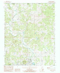
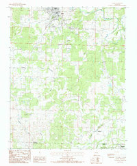 1984 Salem1984 Print · USGSNorth central Arkansas in the early eighties centers on the town of Salem, a landscape of winding Ozark creeks and small crossroads communities. Local historians can trace family roots through the settlements of Wheeling and Morriston or locate specific landmarks like Wheeler Spring and Pinhook Bend.
 - 1984 Map of Salem Knob
 1984 Salem Knob1984 Print · USGSNear the Missouri-Arkansas line in the 1980s, this area of the Ozarks shows a landscape defined by the South Fork Spring River. Researchers can locate Salem and Sturkie, trace the Hunter Cem, and find landmarks like the Lookout Tower on Salem Knob.
End of results
Showing maps 1-3 of 3
Top cities near Salem
- Cherokee Village historical maps
- Horseshoe Bend historical maps
- Ash Flat historical maps
- Oxford historical maps
- Viola historical maps
- Koshkonong historical maps
See more
Frequently asked questions
- What are the different types of historical maps available for Salem?
- What is the oldest map of Salem?
- Where can I purchase historical maps of Salem for my home or office?
- Where can I download high-res historical maps of Salem?
- Are there historical topographic maps available for Salem?
- Is there historical aerial imagery available for Salem?
- Where are historical maps of Salem sourced from?