1970s Maps of Hot Spring County, Arkansas
Explore 8 historic maps of Hot Spring County from the 1970s. These maps offer a rare glimpse into what life looked like during the 1970s — showing old roads, neighborhoods, homes, and landmarks that have changed or disappeared over time.
Whether you're researching your family's past, planning a metal detecting trip, or studying how Hot Spring County's landscape evolved across the 1970s, these high-resolution maps are a powerful tool for exploring the history of this region.
- Focus on a specific era: All maps on this page are from the 1970s, giving you a focused view of this time period.
- See what’s changed: Compare century-old streets, trails, and buildings to today's modern landscape using overlays and satellite layers.
- Research with precision: Use these maps for genealogy, historical research, land use analysis, or educational projects.
- View, download, or print: Maps are fully viewable online in high resolution, and can be downloaded or printed for your own records.
Start exploring Hot Spring County's history through authentic maps from the 1970s. This is your window into the past.
Hot Spring County, AR maps
(8)- 1970 Map of De Gray, 1972 Print
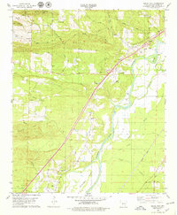
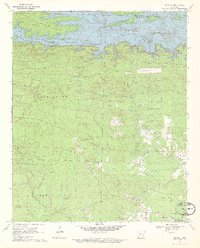 1970 De Gray1972 Print · USGSNear the Arkansas foothills in the early seventies, the landscape shows the recent impact of the De Gray Reservoir on the Caddo River. Researchers can trace old family roots and rural networks through sites like Greenville, Golden Cemetery, and Hearn Church.3 unique versions available
 - 1972 Map of Lonsdale, 1974 Print
 1972 Lonsdale1974 Print · USGSThe Garland and Saline County borderlands in the early seventies reveal a rural landscape defined by the Saline River forks. Researchers can trace family sites at Slate Branch Cem, locate the Rural Dale Sch, or follow the path of the OLD RAILROAD GRADE.4 unique versions available
 - 1972 Map of Fountain Lake, 1974 Print
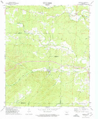
 1972 Fountain Lake1974 Print · USGSGarland County and the surrounding hills were witnessing the early growth of Hot Springs Village and Fountain Lake in the early 1970s. Researchers can trace historic cemeteries and churches such as McClendon Cem, Rockdale Ch, and the Missouri Pacific rail line.3 unique versions available
 - 1974 Map of Haskell, 1977 Print
 1974 Haskell1977 Print · USGSThe Saline River valley in the mid-1970s reveals a transitioning landscape of rural homesteads and emerging infrastructure. Researchers can locate family burial grounds like Grimm Cem, study the MISSOURI PACIFIC rail lines, or trace the grounds of the Benton State Hospital.3 unique versions available
 - 1978 Map of Social Hill, 1979 Print
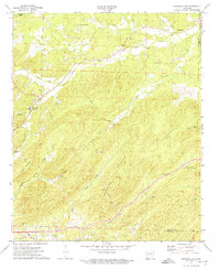
 1978 Social Hill1979 Print · USGSHot Spring County near the Ouachita River in the late seventies was a landscape of timbered ridges and river-bottom agriculture. Researchers can trace genealogical roots through rural sites like Lone Hill Cem, Saginaw Ch, and the community of Midway.
 - 1978 Map of Malvern North, 1979 Print
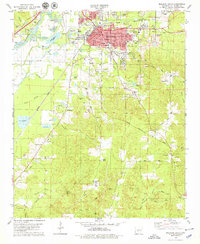
 1978 Malvern North1979 Print · USGSHot Spring County in the late seventies is marked by a heavy industrial landscape surrounding Malvern and Rockport along the Quachita River. Researchers can trace old family landmarks and community sites like Gibson Cem, Magnet Cove Ch, and the historic route of the Old Military Road.2 unique versions available
 - 1978 Map of Lake Catherine, 1979 Print
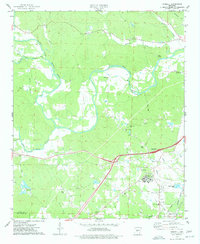
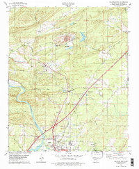
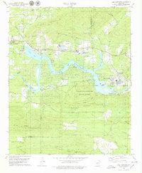 1978 Lake Catherine1979 Print · USGSThe Ouachita River valley comes to life in the late seventies as a hub of hydroelectric power and lakeside recreation. Genealogists and hikers can trace old family sites like Irwin Cem or explore the early development of Lake Catherine State Park and Jones Mills.2 unique versions available
 - 1978 Map of Malvern South, 1979 Print
 1978 Malvern South1979 Print · USGSMalvern and the surrounding Hot Spring County terrain are shown here in the late seventies during a period of industrial mineral extraction. Genealogists and local historians can trace family roots through numerous sites like Oak Ridge Cemetery, Gilead Church, and the rural settlement at Perla.
End of results
Showing maps 1-8 of 8
Top cities of Hot Spring County
- Malvern historical maps
- Rockport historical maps
- Magnet Cove historical maps
- Midway historical maps
- Donaldson historical maps
- Perla historical maps
See more
Frequently asked questions
- What are the different types of historical maps available for Hot Spring County?
- What is the oldest map of Hot Spring County?
- Where can I purchase historical maps of Hot Spring County for my home or office?
- Where can I download high-res historical maps of Hot Spring County?
- Are there historical topographic maps available for Hot Spring County?
- Is there historical aerial imagery available for Hot Spring County?
- Where are historical maps of Hot Spring County sourced from?