1940s Maps of Southside, Arkansas
Explore 2 historic maps of Southside from the 1940s. These maps offer a rare glimpse into what life looked like during the 1940s — showing old roads, neighborhoods, homes, and landmarks that have changed or disappeared over time.
Whether you're researching your family's past, planning a metal detecting trip, or studying how Southside's landscape evolved across the 1940s, these high-resolution maps are a powerful tool for exploring the history of this region.
- Focus on a specific era: All maps on this page are from the 1940s, giving you a focused view of this time period.
- See what’s changed: Compare century-old streets, trails, and buildings to today's modern landscape using overlays and satellite layers.
- Research with precision: Use these maps for genealogy, historical research, land use analysis, or educational projects.
- View, download, or print: Maps are fully viewable online in high resolution, and can be downloaded or printed for your own records.
Start exploring Southside's history through authentic maps from the 1940s. This is your window into the past.
Southside, AR maps
(2)- 1942 Map of Jamestown, 1945 Print
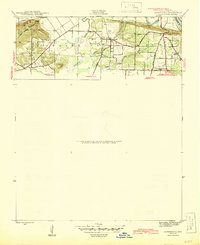 1942 Jamestown1945 Print · USGSIndependence County during the 1940s was a landscape of river-bottom farms and upland ridges shaped by the White River. Researchers can locate rural landmarks like the Enon Powell Sch, Alderbrook Cem, and the historic Cherokee Boundary.3 unique versions available
 - 1942 Map of Salado, 1945 Print
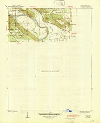 1942 Salado1945 Print · USGSIndependence County along the White River remained a landscape of river-bend settlements and prominent ridges during the 1940s. Genealogists and local historians can trace family landmarks like Montgomery Sprs, Pine Mtn, and the pass at Mountain Gap.2 unique versions available
End of results
Showing maps 1-2 of 2
Top cities near Southside
- Batesville historical maps
- Newark historical maps
- Cushman historical maps
- Sulphur Rock historical maps
- Pleasant Plains historical maps
- Concord historical maps
See more
Top neighborhoods of Southside
- Bryant historical maps
- Dennison Heights historical maps
- Riverview historical maps
- Clearview Estates historical maps
Frequently asked questions
- What are the different types of historical maps available for Southside?
- What is the oldest map of Southside?
- Where can I purchase historical maps of Southside for my home or office?
- Where can I download high-res historical maps of Southside?
- Are there historical topographic maps available for Southside?
- Is there historical aerial imagery available for Southside?
- Where are historical maps of Southside sourced from?