1960s Maps of Horseshoe Bend, Arkansas
Explore 3 historic maps of Horseshoe Bend from the 1960s. These maps offer a rare glimpse into what life looked like during the 1960s — showing old roads, neighborhoods, homes, and landmarks that have changed or disappeared over time.
Whether you're researching your family's past, planning a metal detecting trip, or studying how Horseshoe Bend's landscape evolved across the 1960s, these high-resolution maps are a powerful tool for exploring the history of this region.
- Focus on a specific era: All maps on this page are from the 1960s, giving you a focused view of this time period.
- See what’s changed: Compare century-old streets, trails, and buildings to today's modern landscape using overlays and satellite layers.
- Research with precision: Use these maps for genealogy, historical research, land use analysis, or educational projects.
- View, download, or print: Maps are fully viewable online in high resolution, and can be downloaded or printed for your own records.
Start exploring Horseshoe Bend's history through authentic maps from the 1960s. This is your window into the past.
Horseshoe Bend, AR maps
(3)- 1960 Map of Poplar Bluff
 1960 Poplar Bluff1960 Print · USGSSoutheast Missouri and Northeast Arkansas are captured here during the post-war era, showing the transition from the Ozark highlands to the Delta. Genealogists and historians can trace rail corridors like the St. Louis Southwestern RR and remote settlements such as Birch Tree and Warm Springs.
 - 1962 Map of Myron, 1963 Print
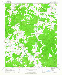 1962 Myron1963 Print · USGSNortheast Arkansas in the early sixties reveals a landscape of isolated farmsteads and quiet river valleys along the Strawberry River. Researchers can trace local lineage through numerous sites like Hills Chapel Cem, Ballard, and the community of Myron.3 unique versions available
 - 1962 Map of Agnos, 1963 Print
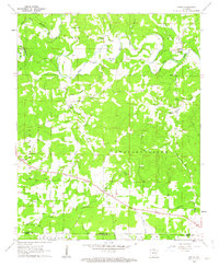 1962 Agnos1963 Print · USGSNorthern Arkansas at the start of the 1960s shows a landscape of ridge-top settlements and winding river forks. Genealogists and local historians can locate rural landmarks like Burks Chapel, follow U.S. Route 62 through Agnos, or find family burial plots at Rhoads Cem.3 unique versions available
End of results
Showing maps 1-3 of 3
Top cities near Horseshoe Bend
- Cherokee Village historical maps
- Melbourne historical maps
- Salem historical maps
- Ash Flat historical maps
- Highland historical maps
- Oxford historical maps
See more
Frequently asked questions
- What are the different types of historical maps available for Horseshoe Bend?
- What is the oldest map of Horseshoe Bend?
- Where can I purchase historical maps of Horseshoe Bend for my home or office?
- Where can I download high-res historical maps of Horseshoe Bend?
- Are there historical topographic maps available for Horseshoe Bend?
- Is there historical aerial imagery available for Horseshoe Bend?
- Where are historical maps of Horseshoe Bend sourced from?