1970s Maps of Jefferson County, Arkansas
Explore 10 historic maps of Jefferson County from the 1970s. These maps offer a rare glimpse into what life looked like during the 1970s — showing old roads, neighborhoods, homes, and landmarks that have changed or disappeared over time.
Whether you're researching your family's past, planning a metal detecting trip, or studying how Jefferson County's landscape evolved across the 1970s, these high-resolution maps are a powerful tool for exploring the history of this region.
- Focus on a specific era: All maps on this page are from the 1970s, giving you a focused view of this time period.
- See what’s changed: Compare century-old streets, trails, and buildings to today's modern landscape using overlays and satellite layers.
- Research with precision: Use these maps for genealogy, historical research, land use analysis, or educational projects.
- View, download, or print: Maps are fully viewable online in high resolution, and can be downloaded or printed for your own records.
Start exploring Jefferson County's history through authentic maps from the 1970s. This is your window into the past.
Jefferson County, AR maps
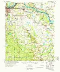
(10)- 1970 Map of Wright, 1972 Print
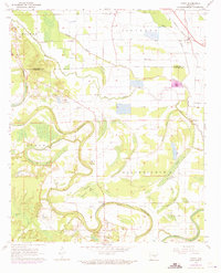
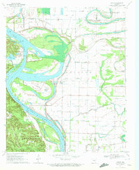 1970 Wright1972 Print · USGSJefferson and Pulaski counties meet along the winding Arkansas River in the early seventies. Genealogists and local historians can trace family landmarks like Watkins Chapel, the Pastoria Sch, and the riverside Tar Camp Public Use Area.2 unique versions available
 - 1970 Map of Hardin, 1972 Print
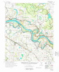
 1970 Hardin1972 Print · USGSJefferson and Grant counties appear here during the early seventies, capturing a transition between small rural settlements and industrial expansion. Researchers can trace family roots at New Shiloh Ch or Hardin Cem, while mapping the impact of the Missouri Pacific RR and Pine Bluff Arsenal.4 unique versions available
 - 1970 Map of White Hall, 1972 Print
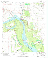
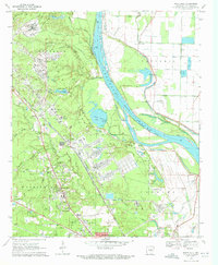 1970 White Hall1972 Print · USGSJefferson County in the early seventies shows a landscape shaped by the river and the massive Pine Bluff Arsenal. Genealogists and historians can trace family locations near Plainview Sch, Morris Chapel, and the riverfront settlement at Pastoria.6 unique versions available
 - 1970 Map of Redfield, 1972 Print
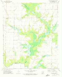
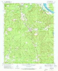 1970 Redfield1972 Print · USGSThe Missouri Pacific railroad and Arkansas River define this Arkansas landscape in the early seventies, spanning from the Saline County line to the edge of the Pine Bluff Arsenal. Researchers can trace old family sites at English Place or find rural landmarks like Garden Springs Ch and Redfield Cem.2 unique versions available
 - 1971 Map of Tarry, 1973 Print
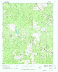
 1971 Tarry1973 Print · USGSThe Arkansas Delta comes to life in this early 1970s survey of the Bayou Bartholomew wetlands and agricultural crossings. Researchers can locate family landmarks such as White Church (Cem) and New Macedonia Ch, or trace the rail stops at Tarry and Tamo.
 - 1972 Map of Gillett, 1974 Print
 1972 Gillett1974 Print · USGSThe Arkansas River meanders through the delta in the early 1970s, shaping the borders of four counties at the confluence of several major bayous. Researchers can locate family landmarks like St Pauls Cem and Moore Cem or trace old river channels at Taylor Old River.
 - 1972 Map of One Horse Store, 1974 Print
 1972 One Horse Store1974 Print · USGSThe Arkansas Delta comes alive in the early seventies, where the local economy revolves around the winding waters of Meto Bayou. Family historians and researchers can locate landmarks like One Horse Store, Van Camp Cem, and the specialized system of Sollars Reservoir.
 - 1973 Map of Cornerstone, 1975 Print
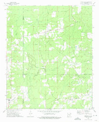 1973 Cornerstone1975 Print · USGSSoutheast Arkansas life in the 1970s is captured here, showing where Cleveland, Lincoln, and Drew counties meet. Genealogists can trace family connections through landmarks like Newton Chapel, Searcy Cem, and the small community of Cornerville.
 - 1978 Map of Noble Lake
 1978 Noble Lake1978 Print · USGSSoutheast of Pine Bluff in the late seventies, this survey captures the transition from river-bend industry to the rural bayou country. Researchers can trace family history through numerous country churches and burial grounds like Macedonia Cem Ch, Smith Chapel Cem., and Hunters Cem.
 - 1978 Map of Varner
 1978 Varner1978 Print · USGSThe Arkansas River bottomlands in the late seventies are a landscape of engineered levees and old river bends. Researchers can locate community centers like Grady, the sprawling Cummins State Prison, and rural landmarks such as Macedonia Ch.
End of results
Showing maps 1-10 of 10
Top cities of Jefferson County
- Pine Bluff historical maps
- White Hall historical maps
- Redfield historical maps
- Altheimer historical maps
- Wabbaseka historical maps
- Sherrill historical maps
Frequently asked questions
- What are the different types of historical maps available for Jefferson County?
- What is the oldest map of Jefferson County?
- Where can I purchase historical maps of Jefferson County for my home or office?
- Where can I download high-res historical maps of Jefferson County?
- Are there historical topographic maps available for Jefferson County?
- Is there historical aerial imagery available for Jefferson County?
- Where are historical maps of Jefferson County sourced from?