1960s Maps of Sherrill, Arkansas
Explore 2 historic maps of Sherrill from the 1960s. These maps offer a rare glimpse into what life looked like during the 1960s — showing old roads, neighborhoods, homes, and landmarks that have changed or disappeared over time.
Whether you're researching your family's past, planning a metal detecting trip, or studying how Sherrill's landscape evolved across the 1960s, these high-resolution maps are a powerful tool for exploring the history of this region.
- Focus on a specific era: All maps on this page are from the 1960s, giving you a focused view of this time period.
- See what’s changed: Compare century-old streets, trails, and buildings to today's modern landscape using overlays and satellite layers.
- Research with precision: Use these maps for genealogy, historical research, land use analysis, or educational projects.
- View, download, or print: Maps are fully viewable online in high resolution, and can be downloaded or printed for your own records.
Start exploring Sherrill's history through authentic maps from the 1960s. This is your window into the past.
Sherrill, AR maps
(2)- 1960 Map of Helena
 1960 Helena1960 Print · USGSThe Arkansas and Mississippi Delta regions meet along the great river bends during a period of significant agricultural and rail expansion. Genealogists and historians can trace the paths of the Missouri Pacific railroad through Clarendon or locate landings along the Mississippi River and White River.
 - 1963 Map of Sherrill, 1965 Print
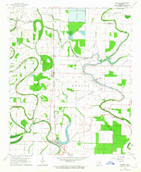 1963 Sherrill1965 Print · USGSThe Arkansas Delta comes to life in the early sixties, showing a landscape defined by the Tucker Prison Farm and the rail-side hamlets of Sherrill and Ferda. Researchers can trace old family burial grounds like Jones Cem and rural spiritual centers such as New Hope Ch along the winding Plum Bayou.2 unique versions available
End of results
Showing maps 1-2 of 2
Top cities near Sherrill
- Pine Bluff historical maps
- White Hall historical maps
- England historical maps
- Redfield historical maps
- Altheimer historical maps
- Wabbaseka historical maps
See more
Frequently asked questions
- What are the different types of historical maps available for Sherrill?
- What is the oldest map of Sherrill?
- Where can I purchase historical maps of Sherrill for my home or office?
- Where can I download high-res historical maps of Sherrill?
- Are there historical topographic maps available for Sherrill?
- Is there historical aerial imagery available for Sherrill?
- Where are historical maps of Sherrill sourced from?