1990s Maps of Subiaco, Arkansas
Explore 3 historic maps of Subiaco from the 1990s. These maps offer a rare glimpse into what life looked like during the 1990s — showing old roads, neighborhoods, homes, and landmarks that have changed or disappeared over time.
Whether you're researching your family's past, planning a metal detecting trip, or studying how Subiaco's landscape evolved across the 1990s, these high-resolution maps are a powerful tool for exploring the history of this region.
- Focus on a specific era: All maps on this page are from the 1990s, giving you a focused view of this time period.
- See what’s changed: Compare century-old streets, trails, and buildings to today's modern landscape using overlays and satellite layers.
- Research with precision: Use these maps for genealogy, historical research, land use analysis, or educational projects.
- View, download, or print: Maps are fully viewable online in high resolution, and can be downloaded or printed for your own records.
Start exploring Subiaco's history through authentic maps from the 1990s. This is your window into the past.
Subiaco, AR maps
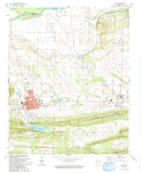
(3)- 1992 Map of Russellville, 1993 Print
 1992 Russellville1993 Print · USGSCentral Arkansas in the early nineties shows a landscape defined by the Arkansas River valley and the surrounding national forests. Trace the development of river towns like Russellville and Dardanelle alongside landmarks such as Lake Dardanelle and Magazine Mtn.
 - 1993 Map of Paris
 1993 Paris1993 Print · USGSLogan County during the early nineties shows a landscape defined by coal mining and monastic tradition. Researchers can trace the legacy of the Paris Gas Field and family history at McKendree Ch Cem, Hixson Cem, and Union Ch.
 - 1993 Map of Scranton
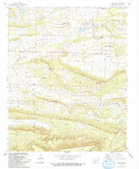 1993 Scranton1993 Print · USGSThe rural landscapes of Logan County are captured here in the early nineties, showing the organized settlements of Scranton and Prairie View amidst a series of prominent ridges. Genealogists can locate numerous burial sites like Saint Meinrads Cem and trace the path of an Old Railroad Grade.
End of results
Showing maps 1-3 of 3
Top cities near Subiaco
- Clarksville historical maps
- Ozark historical maps
- Paris historical maps
- Danville historical maps
- Lamar historical maps
- Coal Hill historical maps
See more
Frequently asked questions
- What are the different types of historical maps available for Subiaco?
- What is the oldest map of Subiaco?
- Where can I purchase historical maps of Subiaco for my home or office?
- Where can I download high-res historical maps of Subiaco?
- Are there historical topographic maps available for Subiaco?
- Is there historical aerial imagery available for Subiaco?
- Where are historical maps of Subiaco sourced from?