1900s (20th Century) Maps of Cabot, Arkansas
Explore 28 historic maps of Cabot from the 1900s (20th Century). These maps offer a rare glimpse into what life looked like during the 1900s — showing old roads, neighborhoods, homes, and landmarks that have changed or disappeared over time.
Whether you're researching your family's past, planning a metal detecting trip, or studying how Cabot's landscape evolved across the 1900s, these high-resolution maps are a powerful tool for exploring the history of this region.
- Focus on a specific era: All maps on this page are from the 1900s, giving you a focused view of this time period.
- See what’s changed: Compare century-old streets, trails, and buildings to today's modern landscape using overlays and satellite layers.
- Research with precision: Use these maps for genealogy, historical research, land use analysis, or educational projects.
- View, download, or print: Maps are fully viewable online in high resolution, and can be downloaded or printed for your own records.
Start exploring Cabot's history through authentic maps from the 1900s. This is your window into the past.
Cabot, AR maps
(28)- 1940 Map of Lonoke
 1940 Lonoke1940 Print · USGSThe Lonoke County interior during the late Depression era shows a landscape of rail-dependent towns and prairie farmsteads. Researchers can trace the early road network and family history through sites like Butlerville, the Confederate Cemetery, and Carlisle.
 - 1941 Map of Cabot, 1945 Print
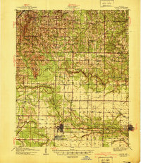
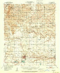
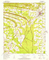
 1941 Cabot1945 Print · USGSLonoke and Pulaski counties are captured in detail during the early 1940s, showing a landscape defined by prominent ridges and the Missouri Pacific rail line. Researchers can trace family sites near Concord Cem or locate historic rural centers like Holland and Mt Tabor Ch.2 unique versions available
 - 1948 Map of Helena
 1948 Helena1948 Print · USGSEastern Arkansas and the Mississippi Delta are captured here just after the war, showing a landscape defined by its great rivers and rail lines. Genealogists can trace family locations near Bemis Plantation, Helena, and smaller rail stops like Wheatley and Moro.
 - 1949 Map of Lonoke
 1949 Lonoke1949 Print · USGSLonoke and Carlisle are captured in the late thirties, when the Chicago Rock Island and Pacific railroad defined the local corridor. Genealogists can trace family footprints at the Camp Nelson Confederate Cem and rural schools like Pittman Sch or Bethlehem Sch.
 - 1950 Map of Helena
 1950 Helena1950 Print · USGSMid-century Phillips County and the surrounding Delta region are shown at a peak of rail and river commerce. Genealogists and historians can trace family locations through numerous rural communities like Old Austin, Cotton Plant, and West Helena, or follow the routes of the Missouri Pacific RR across Grand Prairie.2 unique versions available
 - 1950 Map of Lonoke, 1952 Print
 1950 Lonoke1952 Print · USGSLonoke and Carlisle are centered in this mid-century survey of central Arkansas, highlighting a landscape shaped by rail and river. Genealogists can trace family roots at Camp Nelson Confederate Cem or locate rural landmarks like Jacksons Store and Sylvania.2 unique versions available
 - 1954 Map of Cabot, 1957 Print
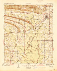
 1954 Cabot1957 Print · USGSThe Lonoke and Pulaski county line comes alive in the mid-1950s as military expansion meets traditional rail towns. Researchers can trace the early footprint of Little Rock Air Force Base or locate local landmarks like Concord Cemetery and the Midway School.3 unique versions available
 - 1955 Map of Helena, 1967 Print
 1955 Helena1967 Print · USGSThe Arkansas Delta and Mississippi floodplains are captured here in the mid-fifties, during a period of expanding flood control and rail commerce. Researchers can trace the extensive Chicago Rock Island and Pacific RR lines and locate sites like the Arkansas State College Experimental Rice Farm or Friars Point.2 unique versions available
 - 1955 Map of Little Rock, 1978 Print
 1955 Little Rock1978 Print · USGSCentral Arkansas in the mid-fifties exhibits a landscape of growing cities, massive military installations, and mountain reservoirs. Genealogists and historians can trace the industrial Bauxite Mines, regional rail lines, and local landmarks like Antioch Church.
 - 1956 Map of Little Rock
 1956 Little Rock1956 Print · USGSCentral Arkansas in the mid-fifties shows a landscape defined by burgeoning military bases and the timber-and-mineral wealth of the Ouachitas. Genealogists and researchers can trace old rail lines like the Missouri Pacific and find established communities such as Bauxite, Sheridan, and Mabelvale.
 - 1956 Map of Russellville
 1956 Russellville1956 Print · USGSThe Arkansas River valley and the surrounding Boston Mountains are captured here in the mid-fifties, showing a landscape of small timber towns and new reservoirs. Genealogists can trace family roots through upland settlements like Pelsor and Witts Springs or locate the campus of Arkansas Polytechnic College.2 unique versions available
 - 1959 Map of Helena
 1959 Helena1959 Print · USGSThe Arkansas and Mississippi Delta regions are captured here in the late fifties, showing a landscape defined by the Mississippi River and the Grand Prairie. Genealogists and researchers can trace the rail networks of the Illinois Central RR and locate community landmarks like Helena and the White River National Wildlife Refuge.
 - 1960 Map of Little Rock
 1960 Little Rock1960 Print · USGSCentral Arkansas in the late fifties shows a landscape of growing military bases and massive new reservoirs. Local historians can trace the mid-century expansion of Little Rock and Hot Springs alongside the industrial works at Bauxite and the Pine Bluff Arsenal.
 - 1960 Map of Helena
 1960 Helena1960 Print · USGSThe Arkansas and Mississippi Delta regions meet along the great river bends during a period of significant agricultural and rail expansion. Genealogists and historians can trace the paths of the Missouri Pacific railroad through Clarendon or locate landings along the Mississippi River and White River.
 - 1963 Map of Mountain Springs, 1964 Print
 1963 Mountain Springs1964 Print · USGSCentral Arkansas in the early sixties was a landscape of remote ridges and tight-knit rural parishes. Genealogists can trace family names through the Shurley Cem or Barger Cem and locate historic meeting places like Baugh Chapel and Sixteenth Section Ch.3 unique versions available
 - 1964 Map of Russellville
 1964 Russellville1964 Print · USGSMid-century Central Arkansas is defined here by the river-valley towns and the surrounding mountain ranges before the full expansion of the interstate system. Genealogists and historians can trace rail-town development along the Missouri Pacific Railroad and locate landmarks like Arkansas Polytechnic College or Petit Jean State Park.
 - 1964 Map of Little Rock
 1964 Little Rock1964 Print · USGSCentral Arkansas in the mid-sixties is a landscape of mountain ridges, industrial rail lines, and growing military hubs. Researchers can trace the development of Bauxite and Hot Springs or locate rural landmarks like Sparkman and the Pine Bluff Arsenal.
 - 1977 Map of Russellville
 1977 Russellville1977 Print · USGSThe Arkansas River Valley and surrounding Ozark Mountains are documented here during a period of significant postwar growth and infrastructure development. Genealogists and researchers can locate family landmarks such as Mount Carmel Cem, St Josephs Church, and several remote Coal Mine sites along the Missouri Pacific RR line.
 - 1982 Map of Oak Grove
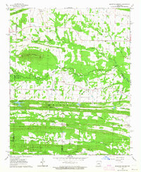
 1982 Oak Grove1982 Print · USGSLonoke County in the early eighties shows a detailed landscape of rural settlements and historic burial grounds. Researchers can trace family history through sites like the Camp Nelson Confederate Cem, Old Austin Cem, and the Sylvania Church.
 - 1983 Map of Conway, 1984 Print
 1983 Conway1984 Print · USGSThe Arkansas River valley in the early eighties shows a landscape of river-bend settlements and expanding wildlife areas. Genealogists and historians can trace the Missouri Pacific RR through old river towns like Toad Suck, Morrilton, and Menifee.
 - 1984 Map of Russellville
 1984 Russellville1984 Print · USGSThe Arkansas River valley was undergoing significant change in the 1950s as transportation and water management reshaped the region from Russellville to Conway. Researchers can trace the era's rail networks like the Missouri Pacific RR and explore landmarks like Magazine Mountain and Petit Jean State Park.
 - 1985 Map of Little Rock, 1988 Print
 1985 Little Rock1988 Print · USGSLittle Rock and its surrounding river valley are shown in the mid-eighties as the region balanced urban expansion with its industrial and military roots. Genealogists and historians can locate dozens of institutions and family landmarks, including Mount Holly Cem, the Bauxite Mines, and Central High Sch.
 - 1986 Map of Brinkley
 1986 Brinkley1986 Print · USGSThe Grand Prairie and White River basin come to life in the mid-1980s, showing the intersection of heavy rail and interstate travel through eastern Arkansas. Genealogists can locate family sites near Sylvania Cem, Oak Grove Ch, and the rural community of De Valls Bluff.
 - 1987 Map of Cabot
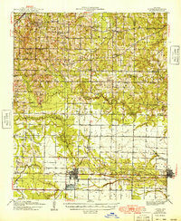
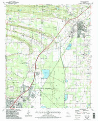 1987 Cabot1987 Print · USGSCabot and Jacksonville were expanding rapidly in the late eighties as the local landscape transitioned from military airbase to residential suburb. Genealogists can locate family landmarks like Concord Cem, Mt Tabor Ch, and the rural homesteads along Backbone Ridge.2 unique versions available
 - 1990 Map of Brinkley, 1991 Print
 1990 Brinkley1991 Print · USGSEastern Arkansas at the start of the 1990s is defined by the agricultural rhythms of the Grand Prairie and the vital White River corridor. Genealogists and historians can trace the rail-linked growth of Brinkley and Des Arc alongside older landmarks like Peckerwood Lake.
Showing maps 1-25 of 28
Top cities near Cabot
- Little Rock historical maps
- North Little Rock historical maps
- Jacksonville historical maps
- Sherwood historical maps
- Beebe historical maps
- Lonoke historical maps
See more
Top neighborhoods of Cabot
- The Meadows Addition historical maps
- Glenwood Estates historical maps
- Meadowlark Addition historical maps
- Spring Valley historical maps
- Windwood Circle historical maps
- Kingwood Addition historical maps
See more
Frequently asked questions
- What are the different types of historical maps available for Cabot?
- What is the oldest map of Cabot?
- Where can I purchase historical maps of Cabot for my home or office?
- Where can I download high-res historical maps of Cabot?
- Are there historical topographic maps available for Cabot?
- Is there historical aerial imagery available for Cabot?
- Where are historical maps of Cabot sourced from?