1940s Maps of England, Arkansas
Explore 2 historic maps of England from the 1940s. These maps offer a rare glimpse into what life looked like during the 1940s — showing old roads, neighborhoods, homes, and landmarks that have changed or disappeared over time.
Whether you're researching your family's past, planning a metal detecting trip, or studying how England's landscape evolved across the 1940s, these high-resolution maps are a powerful tool for exploring the history of this region.
- Focus on a specific era: All maps on this page are from the 1940s, giving you a focused view of this time period.
- See what’s changed: Compare century-old streets, trails, and buildings to today's modern landscape using overlays and satellite layers.
- Research with precision: Use these maps for genealogy, historical research, land use analysis, or educational projects.
- View, download, or print: Maps are fully viewable online in high resolution, and can be downloaded or printed for your own records.
Start exploring England's history through authentic maps from the 1940s. This is your window into the past.
England, AR maps
(2)- 1943 Map of England
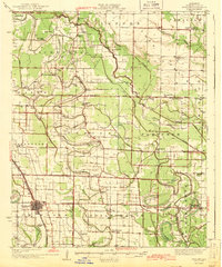 1943 England1943 Print · USGSLonoke County comes into focus just before the mid-century, showing a landscape of delta farming communities and vital rail links. Trace family roots and vanished landmarks through a dense network of country schools and churches like Oldham Sch, Coy, and Zion Chapel.
 - 1948 Map of Helena
 1948 Helena1948 Print · USGSEastern Arkansas and the Mississippi Delta are captured here just after the war, showing a landscape defined by its great rivers and rail lines. Genealogists can trace family locations near Bemis Plantation, Helena, and smaller rail stops like Wheatley and Moro.
End of results
Showing maps 1-2 of 2
Top cities near England
- Little Rock historical maps
- North Little Rock historical maps
- Lonoke historical maps
- Wrightsville historical maps
- Redfield historical maps
- Altheimer historical maps
See more
Frequently asked questions
- What are the different types of historical maps available for England?
- What is the oldest map of England?
- Where can I purchase historical maps of England for my home or office?
- Where can I download high-res historical maps of England?
- Are there historical topographic maps available for England?
- Is there historical aerial imagery available for England?
- Where are historical maps of England sourced from?