1940s Maps of Wabbel, Arkansas
Explore 1 historic maps of Wabbel from the 1940s. These maps offer a rare glimpse into what life looked like during the 1940s — showing old roads, neighborhoods, homes, and landmarks that have changed or disappeared over time.
Whether you're researching your family's past, planning a metal detecting trip, or studying how Wabbel's landscape evolved across the 1940s, these high-resolution maps are a powerful tool for exploring the history of this region.
- Focus on a specific era: All maps on this page are from the 1940s, giving you a focused view of this time period.
- See what’s changed: Compare century-old streets, trails, and buildings to today's modern landscape using overlays and satellite layers.
- Research with precision: Use these maps for genealogy, historical research, land use analysis, or educational projects.
- View, download, or print: Maps are fully viewable online in high resolution, and can be downloaded or printed for your own records.
Start exploring Wabbel's history through authentic maps from the 1940s. This is your window into the past.
Wabbel, AR maps
(1)- 1942 Map of Scott
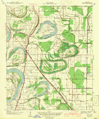 1942 Scott1942 Print · USGSThe alluvial plains east of Little Rock come to life in this early 1940s survey of the Arkansas River oxbows. Researchers can pinpoint the Toltec Mounds and trace a dense network of country schools and churches like Banes Chapel Sch and Mt Hope Ch.2 unique versions available
End of results
Showing maps 1-1 of 1
Top cities near Wabbel
- Little Rock historical maps
- North Little Rock historical maps
- Jacksonville historical maps
- Sherwood historical maps
- Lonoke historical maps
- England historical maps
See more
Frequently asked questions
- What are the different types of historical maps available for Wabbel?
- What is the oldest map of Wabbel?
- Where can I purchase historical maps of Wabbel for my home or office?
- Where can I download high-res historical maps of Wabbel?
- Are there historical topographic maps available for Wabbel?
- Is there historical aerial imagery available for Wabbel?
- Where are historical maps of Wabbel sourced from?