1970s Maps of Bull Shoals, Arkansas
Explore 4 historic maps of Bull Shoals from the 1970s. These maps offer a rare glimpse into what life looked like during the 1970s — showing old roads, neighborhoods, homes, and landmarks that have changed or disappeared over time.
Whether you're researching your family's past, planning a metal detecting trip, or studying how Bull Shoals's landscape evolved across the 1970s, these high-resolution maps are a powerful tool for exploring the history of this region.
- Focus on a specific era: All maps on this page are from the 1970s, giving you a focused view of this time period.
- See what’s changed: Compare century-old streets, trails, and buildings to today's modern landscape using overlays and satellite layers.
- Research with precision: Use these maps for genealogy, historical research, land use analysis, or educational projects.
- View, download, or print: Maps are fully viewable online in high resolution, and can be downloaded or printed for your own records.
Start exploring Bull Shoals's history through authentic maps from the 1970s. This is your window into the past.
Bull Shoals, AR maps
(4)- 1972 Map of Bull Shoals, 1973 Print
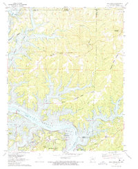 1972 Bull Shoals1973 Print · USGSThe Ozark borderlands in the early 1970s reveal a landscape shaped by the White River and the growth of lakeside communities. Researchers can trace local heritage through landmarks like Newton Flat Cemetery, Oakland School, and the Bull Shoals Caverns.3 unique versions available
 - 1972 Map of Cotter, 1973 Print
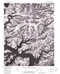
 1972 Cotter1973 Print · USGSThe White River valley in the early seventies shows a landscape shaped by both the massive Bull Shoals Dam and the Missouri Pacific rail line. Researchers can locate family landmarks like Burch Cem, Antioch Ch, and the old McBee Landing.3 unique versions available
 - 1979 Map of Bull Shoals, 1981 Print
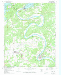
 1979 Bull Shoals1981 Print · USGSNorthern Arkansas at the close of the 1970s is captured in this detailed aerial study of the Ozark shoreline. Researchers can trace the development of lakeside communities like Bull Shoals, Lakeview, and Oakland against the backdrop of Bull Shoals Lake.
 - 1979 Map of Cotter, 1981 Print
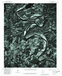 1979 Cotter1981 Print · USGSThe Ozark plateau in the late seventies is revealed through this aerial survey of the river bends and growing towns. Researchers can trace the development of Cotter and Flippin alongside the prominent loops of the White River and Crooked Creek.
End of results
Showing maps 1-4 of 4
Top cities near Bull Shoals
- Mountain Home historical maps
- Gassville historical maps
- Yellville historical maps
- Flippin historical maps
- Cotter historical maps
- Lakeview historical maps
See more
Frequently asked questions
- What are the different types of historical maps available for Bull Shoals?
- What is the oldest map of Bull Shoals?
- Where can I purchase historical maps of Bull Shoals for my home or office?
- Where can I download high-res historical maps of Bull Shoals?
- Are there historical topographic maps available for Bull Shoals?
- Is there historical aerial imagery available for Bull Shoals?
- Where are historical maps of Bull Shoals sourced from?