1940s Maps of Monroe County, Arkansas
Explore 6 historic maps of Monroe County from the 1940s. These maps offer a rare glimpse into what life looked like during the 1940s — showing old roads, neighborhoods, homes, and landmarks that have changed or disappeared over time.
Whether you're researching your family's past, planning a metal detecting trip, or studying how Monroe County's landscape evolved across the 1940s, these high-resolution maps are a powerful tool for exploring the history of this region.
- Focus on a specific era: All maps on this page are from the 1940s, giving you a focused view of this time period.
- See what’s changed: Compare century-old streets, trails, and buildings to today's modern landscape using overlays and satellite layers.
- Research with precision: Use these maps for genealogy, historical research, land use analysis, or educational projects.
- View, download, or print: Maps are fully viewable online in high resolution, and can be downloaded or printed for your own records.
Start exploring Monroe County's history through authentic maps from the 1940s. This is your window into the past.
Monroe County, AR maps
(6)- 1940 Map of Holly Grove, 1942 Print
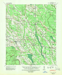 1940 Holly Grove1942 Print · USGSMonroe County was a landscape of rail-driven trade and rural community anchors in the years just before the war. Genealogists and historians can trace dozens of family landmarks, from the Masonic Hall School and Travelers Rest Cem to the local siding at Chimney Spur.2 unique versions available
 - 1940 Map of Brinkley, 1942 Print
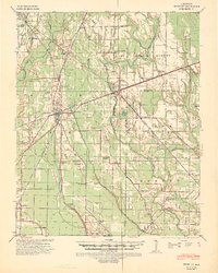 1940 Brinkley1942 Print · USGSBrinkley and the surrounding Delta counties are shown in the 1940s as a bustling junction of three major railroads. Researchers can trace the legacy of local agriculture and community life through sites like Bemis Plantation, Lennon High School, and Garret Grove Ch Sch & Cem.3 unique versions available
 - 1941 Map of De Witt, 1942 Print
 1941 De Witt1942 Print · USGSArkansas County’s rice-growing prairie is shown in detail during the early 1940s, revealing a landscape transformed by intensive irrigation and rail transport. Genealogists and local historians can trace family roots through numerous rural landmarks like Wofford Chapel, Prairieville Sch, and the St Louis Southwestern rail line.
 - 1941 Map of De Valls Bluff, 1943 Print
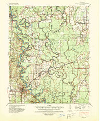 1941 De Valls Bluff1943 Print · USGSThe White River basin in the early 1940s reveals a landscape of complex oxbows and timbered bottomlands. Genealogists and historians can trace family roots through numerous local landmarks like St Johns Cem, Beulah, and the Richland Sch.2 unique versions available
 - 1941 Map of Clarendon, 1946 Print
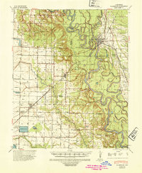 1941 Clarendon1946 Print · USGSThe river-driven economy of the Arkansas delta is on full display here in the early 1940s, centered on the confluence of the White and Cache rivers. Genealogists and historians can trace long-standing landmarks like Preston Ferry, the Ramsey Mill Site, and Lookout Store.2 unique versions available
 - 1948 Map of Helena
 1948 Helena1948 Print · USGSEastern Arkansas and the Mississippi Delta are captured here just after the war, showing a landscape defined by its great rivers and rail lines. Genealogists can trace family locations near Bemis Plantation, Helena, and smaller rail stops like Wheatley and Moro.
End of results
Showing maps 1-6 of 6
Top cities of Monroe County
- Brinkley historical maps
- Clarendon historical maps
- Holly Grove historical maps
- Roe historical maps
- Fargo historical maps
Frequently asked questions
- What are the different types of historical maps available for Monroe County?
- What is the oldest map of Monroe County?
- Where can I purchase historical maps of Monroe County for my home or office?
- Where can I download high-res historical maps of Monroe County?
- Are there historical topographic maps available for Monroe County?
- Is there historical aerial imagery available for Monroe County?
- Where are historical maps of Monroe County sourced from?