1980s Maps of Chasewood Landing, Arkansas
Explore 2 historic maps of Chasewood Landing from the 1980s. These maps offer a rare glimpse into what life looked like during the 1980s — showing old roads, neighborhoods, homes, and landmarks that have changed or disappeared over time.
Whether you're researching your family's past, planning a metal detecting trip, or studying how Chasewood Landing's landscape evolved across the 1980s, these high-resolution maps are a powerful tool for exploring the history of this region.
- Focus on a specific era: All maps on this page are from the 1980s, giving you a focused view of this time period.
- See what’s changed: Compare century-old streets, trails, and buildings to today's modern landscape using overlays and satellite layers.
- Research with precision: Use these maps for genealogy, historical research, land use analysis, or educational projects.
- View, download, or print: Maps are fully viewable online in high resolution, and can be downloaded or printed for your own records.
Start exploring Chasewood Landing's history through authentic maps from the 1980s. This is your window into the past.
Chasewood Landing, AR maps
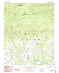
(2)- 1982 Map of Lake Ouachita
 1982 Lake Ouachita1982 Print · USGSThe Ouachita Mountains of West Central Arkansas are shown here during the early eighties, a time of established recreation and protected timberlands. Researchers can locate small communities like Buckville (PO) and Pencil Bluff or trace the drainage of the Fourche La Fave River.
 - 1986 Map of Sims
 1986 Sims1986 Print · USGSThe Ouachita River valley comes to life in the mid-1980s, showing the intersection of national forest lands and rural Montgomery County settlements. Genealogists and hikers can trace local landmarks like Sims, the Harris Trail, and the Lookout Tower atop Muddy Mountain.
End of results
Showing maps 1-2 of 2
Top cities near Chasewood Landing
Frequently asked questions
- What are the different types of historical maps available for Chasewood Landing?
- What is the oldest map of Chasewood Landing?
- Where can I purchase historical maps of Chasewood Landing for my home or office?
- Where can I download high-res historical maps of Chasewood Landing?
- Are there historical topographic maps available for Chasewood Landing?
- Is there historical aerial imagery available for Chasewood Landing?
- Where are historical maps of Chasewood Landing sourced from?