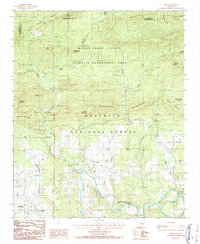
1986 Map of Sims
USGS Topo · Published 1986About this map
The Ouachita River meanders through this portion of Montgomery County, anchoring a landscape defined by the intersection of the Ouachita National Forest and the Muddy Creek State Wildlife Management Area. The settlement of Sims sits at the heart of the valley, surrounded by family-named peaks like Old Mitchel Mountain, John Burns Mountain, and Stoval Mountain. The presence of several Cemeteries and small communities such as Whitetown, Pencil Bluff, and Gibbs provides a clear view of the area's social geography during the mid-1980s.
Find a feature on this map
52 named features on this map. Tap any name to fly to it.
Don’t see what you’re looking for? This feature index may not catch every label — zoom into the map to look around manually.
Map Details
Editions of this 1986 Sims Map
This is the sole edition of this map. No revisions or reprints were ever made.
Other maps of this area

1887 · Mount Ida #2
USGS Topo · 1:62,500

1890 · Mount Ida
USGS Topo · 1:125,000

1955 · Little Rock
USGS Topo · 1:250,000

1956 · Little Rock
USGS Topo · 1:250,000

1959 · Oden
USGS Topo · 1:62,500

1959 · Mount Ida
USGS Topo · 1:62,500

1960 · Little Rock
USGS Topo · 1:250,000

1960 · Gravelly
USGS Topo · 1:62,500
1960 · Parks
USGS Topo · 1:62,500

1964 · Little Rock
USGS Topo · 1:250,000