
1959 Map of Mount Ida
USGS Topo · Published 1960About this map
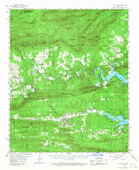
The Ouachita River winds through the heart of Montgomery County, captured here as the landscape was transitioning with the creation of Lake Ouachita. The map shows a system of controlled inundation areas, highlighting where the river's valley was becoming a reservoir. The county seat of Mount Ida serves as a central hub, while smaller communities like Sims, Story, and Pencil Bluff dot the surrounding forest. This 1950s survey documents the rugged Ouachita Mountains before modern development, marking fire lookouts like the Muddy Mountain Lookout Tower and Vanderslice Lookout Tower. Genealogists will find numerous family and community landmarks, including Crystal Hill Ch and several burial grounds such as Macedonia Cem and Stanley Cem, which provide a record of local settlement patterns within the Ouachita National Forest.
Find a feature on this map
115 named features on this map. Tap any name to fly to it.
Don’t see what you’re looking for? This feature index may not catch every label — zoom into the map to look around manually.
Map Details
Editions of this 1959 Mount Ida Map
2 editions found
Other maps of this area

1887 · Mount Ida #2
USGS Topo · 1:62,500

1890 · Mount Ida
USGS Topo · 1:125,000

1890 · Hot Springs
USGS Topo · 1:125,000

1894 · Hot Springs
USGS Topo · 1:125,000

1906 · Caddo Gap
USGS Topo · 1:125,000

1936 · Athens
USGS Topo · 1:48,000

1936 · Glenwood
USGS Topo · 1:48,000

1942 · Glenwood
USGS Topo · 1:62,500

1942 · Athens
USGS Topo · 1:62,500

1949 · Glenwood
USGS Topo · 1:62,500