1900-1909 Maps of Ouachita County, Arkansas
Explore 2 historic maps of Ouachita County from 1900-1909. These maps offer a rare glimpse into what life looked like during the 1900s — showing old roads, neighborhoods, homes, and landmarks that have changed or disappeared over time.
Whether you're researching your family's past, planning a metal detecting trip, or studying how Ouachita County's landscape evolved across the 1900s, these high-resolution maps are a powerful tool for exploring the history of this region.
- Focus on a specific era: All maps on this page are from the 1900s, giving you a focused view of this time period.
- See what’s changed: Compare century-old streets, trails, and buildings to today's modern landscape using overlays and satellite layers.
- Research with precision: Use these maps for genealogy, historical research, land use analysis, or educational projects.
- View, download, or print: Maps are fully viewable online in high resolution, and can be downloaded or printed for your own records.
Start exploring Ouachita County's history through authentic maps from the 1900s. This is your window into the past.
Ouachita County, AR maps
(2)- 1901 Map of Gurdon
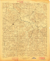 1901 Gurdon1901 Print · USGSSouthwest Arkansas at the dawn of the twentieth century was a landscape defined by the arrival of the rails and the timber industry. Researchers can trace the development of early rail towns like Gurdon, Prescott, and Whelen Springs along the St. Louis Iron Mountain and Southern R. R.3 unique versions available
 - 1903 Map of Camden
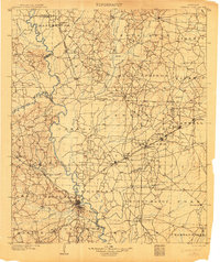 1903 Camden1903 Print · USGSSouth Arkansas at the turn of the century reveals a landscape of river-bend commerce and emerging rail towns along the Ouachita River. Trace family roots in early settlements like Holly Springs, Bearden, and the industrial hub at Eagle Mills.3 unique versions available
End of results
Showing maps 1-2 of 2
Top cities of Ouachita County
- Camden historical maps
- Stephens historical maps
- Bearden historical maps
- East Camden historical maps
- Chidester historical maps
- Louann historical maps
Frequently asked questions
- What are the different types of historical maps available for Ouachita County?
- What is the oldest map of Ouachita County?
- Where can I purchase historical maps of Ouachita County for my home or office?
- Where can I download high-res historical maps of Ouachita County?
- Are there historical topographic maps available for Ouachita County?
- Is there historical aerial imagery available for Ouachita County?
- Where are historical maps of Ouachita County sourced from?