1970s Maps of Ouachita County, Arkansas
Explore 18 historic maps of Ouachita County from the 1970s. These maps offer a rare glimpse into what life looked like during the 1970s — showing old roads, neighborhoods, homes, and landmarks that have changed or disappeared over time.
Whether you're researching your family's past, planning a metal detecting trip, or studying how Ouachita County's landscape evolved across the 1970s, these high-resolution maps are a powerful tool for exploring the history of this region.
- Focus on a specific era: All maps on this page are from the 1970s, giving you a focused view of this time period.
- See what’s changed: Compare century-old streets, trails, and buildings to today's modern landscape using overlays and satellite layers.
- Research with precision: Use these maps for genealogy, historical research, land use analysis, or educational projects.
- View, download, or print: Maps are fully viewable online in high resolution, and can be downloaded or printed for your own records.
Start exploring Ouachita County's history through authentic maps from the 1970s. This is your window into the past.
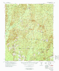
Ouachita County, AR maps
(18)- 1970 Map of Reader, 1972 Print
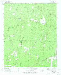
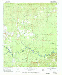 1970 Reader1972 Print · USGSThe Little Missouri River bottomlands and timber country are captured here in the early 1970s. Local researchers can trace family landmarks and rural life at Bethlehem Ch, the Lewis Randolph Grave, and the rail town of Reader.2 unique versions available
 - 1971 Map of Tates Bluff, 1973 Print
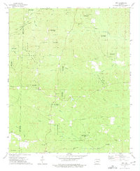
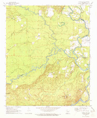 1971 Tates Bluff1973 Print · USGSThe Ouachita and Little Missouri rivers converge here in the early 1970s, forming a complex network of wetlands and river bluffs. Genealogists can locate several family-named landmarks and burial grounds, including Easley Cem, Kansas Cem, and the rural community of Vaden.2 unique versions available
 - 1971 Map of Ouachita, 1973 Print
 1971 Ouachita1973 Print · USGSThe river bottomlands of South Arkansas are captured here in the early 1970s, showing a landscape defined by timber and water. You can trace the path of an abandoned railroad line or locate family landmarks like Smead Ch and the Brazeale Cem.2 unique versions available
 - 1971 Map of Harmony Grove, 1973 Print
 1971 Harmony Grove1973 Print · USGSOuachita County during the early 1970s reveals a landscape defined by the winding Ouachita River and a quiet rural economy. Researchers can trace family history at Rumph Cem or locate the old tracks of the St Louis Southwestern RR near Harmony Grove.2 unique versions available
 - 1971 Map of Camden, 1973 Print
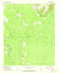
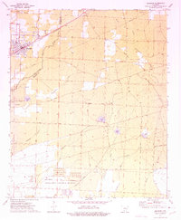
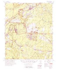
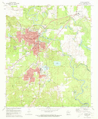 1971 Camden1973 Print · USGSCamden and its riverside suburbs are captured in the early seventies as industrial expansion and timber-hauling railroads defined the local economy. Genealogists can trace family roots at Confederate Cem and Cullendale Cem or locate old neighborhood landmarks like Lincoln High Sch.2 unique versions available
 - 1971 Map of Bragg City, 1973 Print
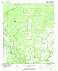
 1971 Bragg City1973 Print · USGSThe Ouachita River valley south of Camden comes into focus during the early 1970s, showcasing a landscape of state forest land and rail-side settlements. Researchers can trace the Missouri Pacific line to Bragg City or locate rural landmarks like Capernaum Ch and Tate Cem.2 unique versions available
 - 1971 Map of Camden SW, 1973 Print
 1971 Camden SW1973 Print · USGSOuachita County during the early 1970s reveals a transition between the developing outskirts of Camden and the rural creek bottoms to the west. Researchers can trace historical family sites and local landmarks like Finnswitch, Pleasant Ridge, and the Mt Olive Cem.2 unique versions available
 - 1972 Map of Gurdon, 1973 Print
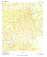
 1972 Gurdon1973 Print · USGSSouthern Arkansas in the early seventies reveals a landscape of river-bottom sloughs, timbered ridges, and deep-seated rural communities. Genealogists and local researchers can trace family landmarks like Harts Chapel Cem, Whelen Springs, and the Lewis Randolph Grave.
 - 1973 Map of Bearden, 1975 Print
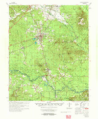
 1973 Bearden1975 Print · USGSBearden and the rural Ouachita County timberlands are caught here during the early seventies, centered on the St Louis Southwestern rail line. Genealogists and local historians can trace old family landmarks like Macedonia Ch, Harlow Cem, and the massive East Camden and Highland Abandoned Ammunition Depot.2 unique versions available
 - 1973 Map of Eagle Mills, 1975 Print
 1973 Eagle Mills1975 Print · USGSOuachita and Calhoun counties appear here in the early seventies during a period of institutional transition. Researchers can trace the massive Abandoned Ammunition Depot alongside local landmarks like Evans Cem, Millville, and Eagle Mills.2 unique versions available
 - 1973 Map of Holly Springs, 1975 Print
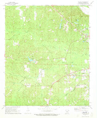
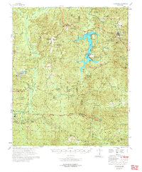
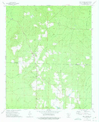 1973 Holly Springs1975 Print · USGSThe Holly Springs area of south-central Arkansas is documented here during the early seventies, showing a landscape defined by creek valleys and timber. Researchers can locate several rural landmarks including Holly Springs Cem, the Holly Springs Lookout Tower, and White Oak Ch.2 unique versions available
 - 1973 Map of East Camden, 1975 Print
 1973 East Camden1975 Print · USGSSouthern Arkansas in the early seventies shows a landscape shaped by military history and the petroleum industry. Researchers can trace rural lineages through Furr Cem and Plunkett Cem or explore the vast ABANDONED AMMUNITION DEPOT.2 unique versions available
 - 1973 Map of Chidester, 1975 Print
 1973 Chidester1975 Print · USGSOuachita and Nevada counties are captured in the early 1970s, as the timberlands and recreation around White Oak Lake took shape. Researchers can locate community centers like Chidester and Good Hope, or trace family roots at Turner Cem and Mt Moriah Ch.
 - 1973 Map of Hopeville, 1975 Print
 1973 Hopeville1975 Print · USGSThe borderlands of Dallas, Ouachita, and Calhoun counties are captured here in the early seventies, a landscape of rural crossroads and timbered creek bottoms. Genealogists can locate family landmarks like Stevenson Cem, Oak Grove Ch, and the settlement of Hopeville.2 unique versions available
 - 1973 Map of Troy, 1975 Print
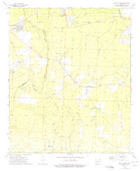
 1973 Troy1975 Print · USGSThe Ouachita and Nevada county lines intersect in this forested Arkansas landscape during the early 1970s. Genealogists and historians can trace numerous rural congregations and burial sites, including Adams Chapel, Round Oak Cem, and the East Troy Oil Field.
 - 1978 Map of Bearden
 1978 Bearden1978 Print · USGSThe Ouachita and Calhoun County borderlands appear here in the late seventies, showing a landscape defined by timber-rail towns and large-scale industrial sites. Researchers can trace family history through sites like Harlow Cem or explore the sprawling grounds of the Abandoned Ammunition Depot.
 - 1978 Map of Chidester
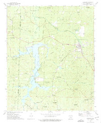
 1978 Chidester1978 Print · USGSThe Poison Springs State Forest and the waters of White Oak Lake characterize this late-seventies landscape on the Nevada and Ouachita county line. Researchers can locate numerous rural landmarks like Dills Mills, Adams Chapel Cem, and Anthony Switch.
 - 1978 Map of Princeton
 1978 Princeton1978 Print · USGSSouth Arkansas rural life is captured here in the late 1970s as timber and rail lines defined the local economy. Researchers can trace family roots at Princeton Cem and Macedonia Ch or locate industrial sites like the Fish Hatchery and numerous Gravel Pits.
End of results
Showing maps 1-18 of 18
Top cities of Ouachita County
- Camden historical maps
- Stephens historical maps
- Bearden historical maps
- East Camden historical maps
- Chidester historical maps
- Louann historical maps
Frequently asked questions
- What are the different types of historical maps available for Ouachita County?
- What is the oldest map of Ouachita County?
- Where can I purchase historical maps of Ouachita County for my home or office?
- Where can I download high-res historical maps of Ouachita County?
- Are there historical topographic maps available for Ouachita County?
- Is there historical aerial imagery available for Ouachita County?
- Where are historical maps of Ouachita County sourced from?