1900s (20th Century) Maps of Daisy, Arkansas
Explore 11 historic maps of Daisy from the 1900s (20th Century). These maps offer a rare glimpse into what life looked like during the 1900s — showing old roads, neighborhoods, homes, and landmarks that have changed or disappeared over time.
Whether you're researching your family's past, planning a metal detecting trip, or studying how Daisy's landscape evolved across the 1900s, these high-resolution maps are a powerful tool for exploring the history of this region.
- Focus on a specific era: All maps on this page are from the 1900s, giving you a focused view of this time period.
- See what’s changed: Compare century-old streets, trails, and buildings to today's modern landscape using overlays and satellite layers.
- Research with precision: Use these maps for genealogy, historical research, land use analysis, or educational projects.
- View, download, or print: Maps are fully viewable online in high resolution, and can be downloaded or printed for your own records.
Start exploring Daisy's history through authentic maps from the 1900s. This is your window into the past.
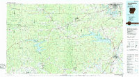
Daisy, AR maps
(11)- 1906 Map of Caddo Gap
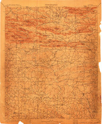 1906 Caddo Gap1906 Print · USGSWest-central Arkansas at the dawn of the twentieth century shows a rugged landscape defined by the Ouachita ridges and early mountain industries. Researchers can trace defunct mining communities like Slatington and Fancy Hill, or locate long-gone railway stops at Hickory Station and Brocktown.3 unique versions available
 - 1955 Map of Little Rock, 1978 Print
 1955 Little Rock1978 Print · USGSCentral Arkansas in the mid-fifties exhibits a landscape of growing cities, massive military installations, and mountain reservoirs. Genealogists and historians can trace the industrial Bauxite Mines, regional rail lines, and local landmarks like Antioch Church.
 - 1956 Map of Little Rock
 1956 Little Rock1956 Print · USGSCentral Arkansas in the mid-fifties shows a landscape defined by burgeoning military bases and the timber-and-mineral wealth of the Ouachitas. Genealogists and researchers can trace old rail lines like the Missouri Pacific and find established communities such as Bauxite, Sheridan, and Mabelvale.
 - 1960 Map of Little Rock
 1960 Little Rock1960 Print · USGSCentral Arkansas in the late fifties shows a landscape of growing military bases and massive new reservoirs. Local historians can trace the mid-century expansion of Little Rock and Hot Springs alongside the industrial works at Bauxite and the Pine Bluff Arsenal.
 - 1964 Map of Little Rock
 1964 Little Rock1964 Print · USGSCentral Arkansas in the mid-sixties is a landscape of mountain ridges, industrial rail lines, and growing military hubs. Researchers can trace the development of Bauxite and Hot Springs or locate rural landmarks like Sparkman and the Pine Bluff Arsenal.
 - 1969 Map of Narrows Dam, 1972 Print
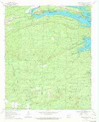
 1969 Narrows Dam1972 Print · USGSPike County's landscape was defined by the waters of the Little Missouri River and the surrounding ridges in the late sixties. Trace the development of Lake Greeson alongside older landmarks like Midway Cem, the settlement of Kirby, and the engineering of Narrows Dam.2 unique versions available
 - 1970 Map of Center Point NE, 1972 Print
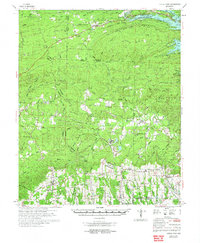
 1970 Center Point NE1972 Print · USGSPike and Howard counties in the early 1970s showcase a landscape where recreational development met rural tradition. Genealogists and hikers can trace sites like Eden Landmark Ch, the Shiloh Cem, and the high points of White Mountain.
 - 1972 Map of Center Point, 1973 Print
 1972 Center Point1973 Print · USGSHoward and Pike counties are captured here in the early seventies, just as the region's timber and rail industries shaped the local landscape. Researchers can trace the routes of the Mississippi Southwestern Railroad and locate historic community centers like Corinth, Highland, and the Antioch Cem.
 - 1972 Map of Murfreesboro, 1973 Print
 1972 Murfreesboro1973 Print · USGSPike County in the early seventies shows a landscape shaped by the waters of Lake Greeson and the unique geology of the Little Missouri River valley. Genealogists and historians can locate the Crater of Diamonds, the Indian Mounds, and rural landmarks like Pleasant Home Ch.
 - 1980 Map of Narrows Dam, 1982 Print
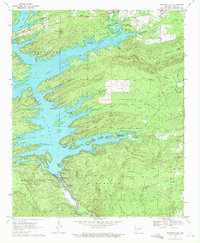
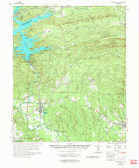
 1980 Narrows Dam1982 Print · USGSThe wooded highlands of Pike County are captured here in the early eighties, centered on the winding waters of the reservoir. Researchers can trace the shoreline near Daisy and Kirby or study the engineering of the Narrows Dam.2 unique versions available
 - 1986 Map of Arkadelphia
 1986 Arkadelphia1986 Print · USGSSouthwest Arkansas in the mid-eighties shows a landscape of timbered ridges and significant new reservoirs. Researchers can trace rural schoolhouses and churches like Sunshine Sch and Hempwallace Ch alongside the famous Crater of Diamonds State Park.2 unique versions available
End of results
Showing maps 1-11 of 11
Top cities near Daisy
Frequently asked questions
- What are the different types of historical maps available for Daisy?
- What is the oldest map of Daisy?
- Where can I purchase historical maps of Daisy for my home or office?
- Where can I download high-res historical maps of Daisy?
- Are there historical topographic maps available for Daisy?
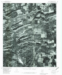
- Is there historical aerial imagery available for Daisy?
- Where are historical maps of Daisy sourced from?