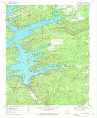
1969 Map of Narrows Dam
USGS Topo · Published 1972About this map
Lake Greeson dominates this late-1960s landscape, its jagged shoreline reaching deep into the forested valleys of the Ouachita foothills. The massive Narrows Dam impounds the Little Missouri River, creating a complex of recreation areas such as Daisy State Park and Cowhide Cove Public Use Area. The map reveals a transition from the water-focused economy of the reservoir to the highland ridges of Antoine Mountain and Skelton Mountain.
Find a feature on this map
62 named features on this map. Tap any name to fly to it.
Don’t see what you’re looking for? This feature index may not catch every label — zoom into the map to look around manually.
Map Details
Editions of this 1969 Narrows Dam Map
2 editions found
Other maps of this area

1906 · Caddo Gap
USGS Topo · 1:125,000

1936 · Athens
USGS Topo · 1:48,000

1936 · Glenwood
USGS Topo · 1:48,000

1942 · Glenwood
USGS Topo · 1:62,500

1942 · Athens
USGS Topo · 1:62,500

1949 · Glenwood
USGS Topo · 1:62,500

1955 · Little Rock
USGS Topo · 1:250,000

1956 · Little Rock
USGS Topo · 1:250,000

1960 · Little Rock
USGS Topo · 1:250,000

1964 · Little Rock
USGS Topo · 1:250,000