Old Maps of Pope County, Arkansas for Hiking & Exploration
Hike through history with 185 historic maps of Pope County. Explore old trails, ghost towns, and forgotten backroads — perfect for outdoor adventurers and local explorers.
- Rediscover forgotten places: Map out old mining camps, roads, and footpaths that no longer exist on modern maps.
- Layer with modern tools: Combine with LiDAR or satellite views to plan hikes through historical terrain.
- Made for exploration: Popular among hikers, overlanders, and local history lovers.
Use these maps to find adventure and explore the hidden past of Pope County.
Pope County, AR maps
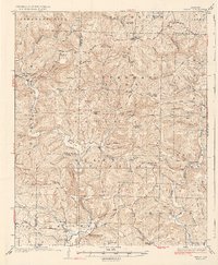
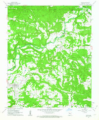
(185)- 1879 Map of Washington
 1879 Washington1879 Print · USGSThe Arkansas backcountry in the late 1870s is captured in this focused survey of the Ozark foothills. Researchers can trace the rugged headwaters of Illinois Creek and identify landmarks like Grapevine Mountain and Longs Spr.
 - 1887 Map of Smyrna
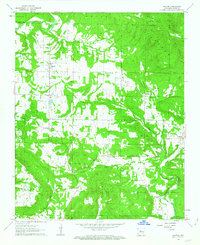
 1887 Smyrna1887 Print · USGSIn the late 1880s, the Smyrna area of Pope County was a landscape of steep Ozark elevations and winding waterways. Genealogists and hikers can trace the original paths of Illinois Creek and Hurricane Cr as they flow around the base of Grapevine Mountain.
 - 1888 Map of Dardanelle #4
 1888 Dardanelle #41888 Print · USGSDardanelle and the Arkansas River valley are shown here in the late nineteenth century as the regional rail network began to expand. Genealogists and historians can trace early settlements and landings like Centerville, Galla Rock, and Morristown.
 - 1888 Map of Dardanelle #2
 1888 Dardanelle #21888 Print · USGSJohnson County’s river-and-rail economy is captured here in the late 1880s as the Little Rock & Fort Smith R. R. spurred growth along the Arkansas River. Genealogists and researchers can trace early homesteads near Knoxville, find the river Ferry, and locate settlements like Lutherville and Blaine.
 - 1888 Map of Dardanelle #1
 1888 Dardanelle #11888 Print · USGSPope County at the end of the 1880s was a landscape of rising ridges and vital new rail connections. Family historians can trace early homesteads near Dover and Scottsville, or follow the old tracks of the Little Rock and Fort Smith Railway.
 - 1889 Map of Morrilton No. 3
 1889 Morrilton No. 31889 Print · USGSNear the end of the nineteenth century, the Arkansas River valley was defined by the massive plateau of Petit Jean Mountain. Genealogists can trace early homesteads in Atkins or near rural centers like Ada, Divide, and the river lands of Gardens Bottoms.
 - 1889 Map of Treat
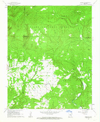
 1889 Treat1889 Print · USGSInland Pope County is shown in this rare nineteenth-century advance sheet during the early geological survey of the state. Researchers can trace the original topography around the Laurel settlement and family-named landmarks like Evans Hill and Levi Br.
 - 1889 Map of Marshall #3
 1889 Marshall #31889 Print · USGSThe Arkansas Ozarks come into focus in the late nineteenth century as early surveyors mapped the headwaters of the Illinois Bayou. Researchers can trace the steep elevations of Grapevine Mountain and locate early landmarks like Longs Spr and the East Fork.
 - 1890 Map of Dardanelle
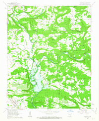
 1890 Dardanelle1890 Print · USGSThe Arkansas River valley was a primary corridor of settlement in the 1890s, anchored by the river towns of Dardanelle and Russellville. Genealogists can locate early homesteads near Mt. Nebo, Lutherville, or the old post office at Chickalah.7 unique versions available
 - 1892 Map of Marshall
 1892 Marshall1892 Print · USGSThe Ozark highlands of Searcy and Van Buren Counties appear here in the early 1890s, characterized by isolated mountain settlements and complex river headwaters. Genealogists can trace early homesteads and family-named landmarks such as Wileys Cove, Hendersons Knob, and Witts Springs.
 - 1892 Map of Morrillton
 1892 Morrillton1892 Print · USGSThe Arkansas River valley at the end of the nineteenth century was a landscape of vital ferry crossings and early rail expansion. Genealogists and historians can trace the foundations of Morrillton and Perryville or locate river landmarks like Galla Rock Fy. and Stouts Ldg.
 - 1894 Map of Morrillton
 1894 Morrillton1894 Print · USGSThe Arkansas River valley and the Ouachita foothills meet in the 1890s, where river traffic and the rail line define the local economy. Genealogists can trace early homesteads and crossings near Morrillton, Burnetts Ford, and the rugged heights of Cedar Falls Mt.5 unique versions available
 - 1894 Map of Marshall
 1894 Marshall1894 Print · USGSThe Ozark plateau in the 1890s reveals a sparse network of mountain settlements and family landmarks. Genealogists can locate early community centers like Snow Ball and Witts Springs or trace ancestral lands near Point Peter and Hendersons Knob.
 - 1901 Map of Marshall
 1901 Marshall1901 Print · USGSThe Ozark plateau in the 1890s reveals a rugged network of high ridges and river forks where isolation defined early settlement. Genealogists can trace family roots through upland communities like Snowball, Witts Springs, and Wileys Cove before modern infrastructure reached the Boston Mountain range.4 unique versions available
 - 1932 Map of Treat, 1972 Print
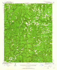
 1932 Treat1972 Print · USGSThe Arkansas Ozarks come alive in this early 1930s survey of the Piney Creek highlands. Researchers can trace rural life through numerous one-room schools like Ross Sch and remote outposts like Sand Gap Felsor PO or Fort Douglas.
 - 1934 Map of Treat
 1934 Treat1934 Print · USGSPope County highlands during the early thirties show a rugged network of forest outposts and mountain schools. Researchers can trace the layout of community sites like Sand Gap Pelsor PO, Ross Sch, and the Fairview Fire Tower.3 unique versions available
 - 1940 Map of Smyrna, 1961 Print
 1940 Smyrna1961 Print · USGSThe Arkansas Ozarks around the Pope and Searcy county lines are shown here at a time when small mountain schools and isolated settlements were the heart of the community. Researchers can trace family roots at Old Smyrna Cem or find the sites of vanished homesteads near Lost Corner and Nogo Sch.2 unique versions available
 - 1943 Map of Smyrna
 1943 Smyrna1943 Print · USGSThe Boston Mountains of Pope and Van Buren counties appear in the early 1940s as a landscape of isolated ridges and headwater creeks. Genealogists and historians can trace the foundations of rural life at Old Smyrna Cem, Union Hill Sch, and the remote settlement of Nogo.
 - 1956 Map of Russellville
 1956 Russellville1956 Print · USGSThe Arkansas River valley and the surrounding Boston Mountains are captured here in the mid-fifties, showing a landscape of small timber towns and new reservoirs. Genealogists can trace family roots through upland settlements like Pelsor and Witts Springs or locate the campus of Arkansas Polytechnic College.2 unique versions available
 - 1961 Map of Morrilton West, 1962 Print
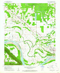 1961 Morrilton West1962 Print · USGSThe Arkansas River valley at the foot of the Ozarks is captured here in the early sixties, showing the vital river-and-rail corridor near Morrilton. Local historians can trace family ties at Happy Bend Cem and Elmwood Cem or locate industrial sites like the Shale Pit.3 unique versions available
 - 1961 Map of Atkins, 1962 Print
 1961 Atkins1962 Print · USGSThe Arkansas River valley comes alive in this early 1960s survey of Pope and Yell counties, showing the transition from delta bottomlands to the heights of Petit Jean Mountain. Genealogists can trace rural roots through landmarks like Bells Chapel Cem, Gold Hill Sch, and the riverside site of Galla Rock.3 unique versions available
 - 1961 Map of Dover, 1963 Print
 1961 Dover1963 Print · USGSPope County enters the early sixties as a landscape of river-valley farms and timbered highlands. Researchers can locate family landmarks like McFadden Cem, rural congregations at Fairview Ch, and the early industrial footprint of local Gas Wells.3 unique versions available
 - 1962 Map of Hector, 1963 Print
 1962 Hector1963 Print · USGSPope County enters the 1960s as a landscape of mountain ridges and tight-knit rural communities. Genealogists and historians can trace family roots through landmarks like Kinslow Cem, Rock Springs Ch, and the high-elevation Peterman Lookout Tower.2 unique versions available
 - 1962 Map of Knoxville, 1963 Print
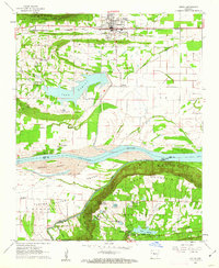
 1962 Knoxville1963 Print · USGSKnoxville and its surrounding ridges are captured here in the early 1960s, just as the Dardanelle Reservoir was reshaping the Arkansas River valley. Genealogists and local historians can locate remote landmarks like Maddin Chapel, Lutherville, and the Cazort Cem.2 unique versions available
 - 1962 Map of Jerusalem, 1963 Print
 1962 Jerusalem1963 Print · USGSThe rural Arkansas Ozarks come into focus in the early sixties, showing a landscape of mountain settlements and forest ridges. Genealogists can trace family landmarks like Thompson Cem, Mt Zion Ch, and the high-elevation hamlet of Stumptoe.4 unique versions available
Showing maps 1-25 of 185
Top cities of Pope County
- Russellville historical maps
- Atkins historical maps
- Pottsville historical maps
- Dover historical maps
- London historical maps
- Hector historical maps
Frequently asked questions
- What are the different types of historical maps available for Pope County?
- What is the oldest map of Pope County?
- Where can I purchase historical maps of Pope County for my home or office?
- Where can I download high-res historical maps of Pope County?
- Are there historical topographic maps available for Pope County?
- Is there historical aerial imagery available for Pope County?
- Where are historical maps of Pope County sourced from?