1960s Maps of Hazen, Arkansas
Explore 5 historic maps of Hazen from the 1960s. These maps offer a rare glimpse into what life looked like during the 1960s — showing old roads, neighborhoods, homes, and landmarks that have changed or disappeared over time.
Whether you're researching your family's past, planning a metal detecting trip, or studying how Hazen's landscape evolved across the 1960s, these high-resolution maps are a powerful tool for exploring the history of this region.
- Focus on a specific era: All maps on this page are from the 1960s, giving you a focused view of this time period.
- See what’s changed: Compare century-old streets, trails, and buildings to today's modern landscape using overlays and satellite layers.
- Research with precision: Use these maps for genealogy, historical research, land use analysis, or educational projects.
- View, download, or print: Maps are fully viewable online in high resolution, and can be downloaded or printed for your own records.
Start exploring Hazen's history through authentic maps from the 1960s. This is your window into the past.
Hazen, AR maps
(5)- 1960 Map of Helena
 1960 Helena1960 Print · USGSThe Arkansas and Mississippi Delta regions meet along the great river bends during a period of significant agricultural and rail expansion. Genealogists and historians can trace the paths of the Missouri Pacific railroad through Clarendon or locate landings along the Mississippi River and White River.
 - 1964 Map of Hazen, 1965 Print
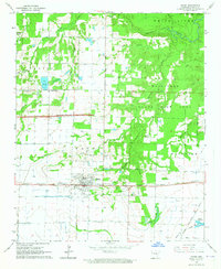 1964 Hazen1965 Print · USGSHazen and the surrounding Prairie County lowlands are captured here in the mid-1960s as a vital rail and agricultural corridor. Researchers can trace the Chicago Rock Island and Pacific line, locate the Old Bethel Cem, or explore the wooded Wattensaw State Game Area.3 unique versions available
 - 1964 Map of Carlisle, 1965 Print
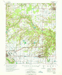
 1964 Carlisle1965 Print · USGSLonoke and Prairie Counties appear here during a period of infrastructure expansion in the mid-1960s. Researchers can trace the Chicago Rock Island and Pacific railroad or locate local landmarks like Mt Zion Cemetery and Screeton.
 - 1967 Map of Hazen
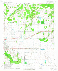
 1967 Hazen1967 Print · USGSPrairie and Lonoke Counties come into focus in the mid-1960s as industrial transport and local agriculture intersect. Genealogists and historians can trace family sites at Tucker Cem, New Bethel Ch, and the rail stops along the Chicago Rock Island and Pacific.
 - 1968 Map of De Valls Bluff, 1970 Print
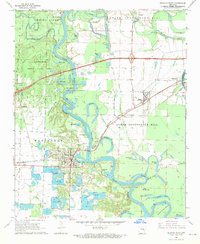 1968 De Valls Bluff1970 Print · USGSPrairie County in the late sixties reveals a landscape of river-bottom commerce and rail connectivity along the White River. Trace the old rail lines and pioneer burials at Oaklawn Cem or family-named landmarks like Pfennighausen Ridge.3 unique versions available
End of results
Showing maps 1-5 of 5
Top cities near Hazen
- Carlisle historical maps
- Des Arc historical maps
- De Valls Bluff historical maps
- Fredonia (Biscoe) historical maps
- Ulm historical maps
- Roe historical maps
Frequently asked questions
- What are the different types of historical maps available for Hazen?
- What is the oldest map of Hazen?
- Where can I purchase historical maps of Hazen for my home or office?
- Where can I download high-res historical maps of Hazen?
- Are there historical topographic maps available for Hazen?
- Is there historical aerial imagery available for Hazen?
- Where are historical maps of Hazen sourced from?