1970s Maps of North Little Rock, Arkansas
Explore 5 historic maps of North Little Rock from the 1970s. These maps offer a rare glimpse into what life looked like during the 1970s — showing old roads, neighborhoods, homes, and landmarks that have changed or disappeared over time.
Whether you're researching your family's past, planning a metal detecting trip, or studying how North Little Rock's landscape evolved across the 1970s, these high-resolution maps are a powerful tool for exploring the history of this region.
- Focus on a specific era: All maps on this page are from the 1970s, giving you a focused view of this time period.
- See what’s changed: Compare century-old streets, trails, and buildings to today's modern landscape using overlays and satellite layers.
- Research with precision: Use these maps for genealogy, historical research, land use analysis, or educational projects.
- View, download, or print: Maps are fully viewable online in high resolution, and can be downloaded or printed for your own records.
Start exploring North Little Rock's history through authentic maps from the 1970s. This is your window into the past.
North Little Rock, AR maps
(5)- 1975 Map of Sweet Home, 1976 Print
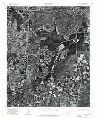
 1975 Sweet Home1976 Print · USGSThe Arkansas capital and its riverfront are captured in the mid-seventies just as the urban landscape met the fertile floodplains. Genealogists and researchers can trace the roads and properties around Sweet Home and the banks of the Arkansas River.
 - 1975 Map of Mc Almont, 1976 Print
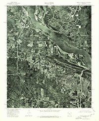
 1975 Mc Almont1976 Print · USGSNorth Little Rock and the surrounding river valley are captured in this mid-seventies aerial perspective as suburban growth began to bridge the gap toward Jacksonville. Researchers can trace the precise 1975 footprint of residential blocks and industrial sites near Mc Almont.
 - 1975 Map of Little Rock, 1976 Print
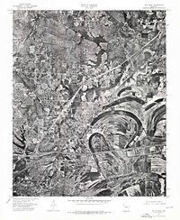
 1975 Little Rock1976 Print · USGSLittle Rock and its surrounding landscape are revealed in detailed aerial photography from the mid-seventies. Researchers can trace the exact footprint of urban neighborhoods near the Arkansas R and the density of Little Rock at this moment in time.
 - 1975 Map of Pinnacle Mountain, 1976 Print
 1975 Pinnacle Mountain1976 Print · USGSCentral Arkansas in the mid-seventies shows a landscape of sharp relief and growing communities along the water. Researchers can trace the development near Pinnacle Mountain and the winding confluence of the Arkansas River and Maumelle River.
 - 1975 Map of North Little Rock, 1976 Print
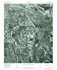
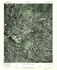 1975 North Little Rock1976 Print · USGSCentral Arkansas comes into sharp focus during the mid-1970s through this aerial-based survey of the riverfront. Researchers can trace the development of North Little Rock and the industrial activity along the Arkansas River.
End of results
Showing maps 1-5 of 5
Top cities near North Little Rock
- Little Rock historical maps
- Conway historical maps
- Jacksonville historical maps
- Cabot historical maps
- Sherwood historical maps
- Maumelle historical maps
See more
Top neighborhoods of North Little Rock
- Levy historical maps
- Protho Junction historical maps
- Tanglewood historical maps
- Amboy historical maps
- Timber Creek historical maps
- Galloway historical maps
See more
Frequently asked questions
- What are the different types of historical maps available for North Little Rock?
- What is the oldest map of North Little Rock?
- Where can I purchase historical maps of North Little Rock for my home or office?
- Where can I download high-res historical maps of North Little Rock?
- Are there historical topographic maps available for North Little Rock?
- Is there historical aerial imagery available for North Little Rock?
- Where are historical maps of North Little Rock sourced from?