1950s Maps of Central City, Arkansas
Explore 2 historic maps of Central City from the 1950s. These maps offer a rare glimpse into what life looked like during the 1950s — showing old roads, neighborhoods, homes, and landmarks that have changed or disappeared over time.
Whether you're researching your family's past, planning a metal detecting trip, or studying how Central City's landscape evolved across the 1950s, these high-resolution maps are a powerful tool for exploring the history of this region.
- Focus on a specific era: All maps on this page are from the 1950s, giving you a focused view of this time period.
- See what’s changed: Compare century-old streets, trails, and buildings to today's modern landscape using overlays and satellite layers.
- Research with precision: Use these maps for genealogy, historical research, land use analysis, or educational projects.
- View, download, or print: Maps are fully viewable online in high resolution, and can be downloaded or printed for your own records.
Start exploring Central City's history through authentic maps from the 1950s. This is your window into the past.
Central City, AR maps
(2)- 1951 Map of Barling
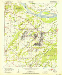 1951 Barling1951 Print · USGSThe military expansion at Camp Chaffee and the riverside life of Sebastian County are captured here in the years following the war. Researchers can trace family sites near New Jenny Lind or locate the St Marys Ch and Sch and various local coal mines.2 unique versions available
 - 1951 Map of Lavaca
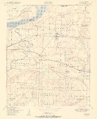 1951 Lavaca1951 Print · USGSSebastian County is captured here in the early fifties as the Arkansas River landscape met the expanding footprint of the military. Genealogists and historians can trace family locations near Lavaca, Bloomer School, and Red Oak Cemetery.2 unique versions available
End of results
Showing maps 1-2 of 2
Top cities near Central City
- Fort Smith historical maps
- Van Buren historical maps
- Greenwood historical maps
- Alma historical maps
- Barling historical maps
- Pocola historical maps
See more
Frequently asked questions
- What are the different types of historical maps available for Central City?
- What is the oldest map of Central City?
- Where can I purchase historical maps of Central City for my home or office?
- Where can I download high-res historical maps of Central City?
- Are there historical topographic maps available for Central City?
- Is there historical aerial imagery available for Central City?
- Where are historical maps of Central City sourced from?