1990s Maps of Bethel Heights, Springdale
Explore 2 historic maps of Bethel Heights from the 1990s. These maps offer a rare glimpse into what life looked like during the 1990s — showing old roads, neighborhoods, homes, and landmarks that have changed or disappeared over time.
Whether you're researching your family's past, planning a metal detecting trip, or studying how Bethel Heights's landscape evolved across the 1990s, these high-resolution maps are a powerful tool for exploring the history of this region.
- Focus on a specific era: All maps on this page are from the 1990s, giving you a focused view of this time period.
- See what’s changed: Compare century-old streets, trails, and buildings to today's modern landscape using overlays and satellite layers.
- Research with precision: Use these maps for genealogy, historical research, land use analysis, or educational projects.
- View, download, or print: Maps are fully viewable online in high resolution, and can be downloaded or printed for your own records.
Start exploring Bethel Heights's history through authentic maps from the 1990s. This is your window into the past.
Bethel Heights, Springdale maps
(2)- 1994 Map of Springdale, 1998 Print
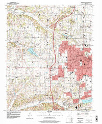 1994 Springdale1998 Print · USGSNorthwest Arkansas was undergoing rapid expansion in the 1990s as the urban centers of Springdale and Johnson began to merge. Researchers can trace family sites and old landmarks like Silent Grove Ch, Lake Elmdale, and the St Louis-San Francisco RR.
 - 1994 Map of Sonora, 1998 Print
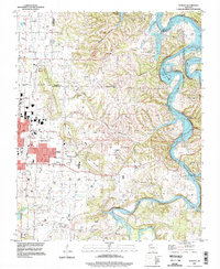 1994 Sonora1998 Print · USGSThe White River valley east of Springdale comes into focus in the mid-1990s as suburban growth meets rural Arkansas tradition. Genealogists and local historians can trace legacy sites like Accident Sch, Phillips Cem, and the small settlement of Sonora.
End of results
Showing maps 1-2 of 2
Top cities near Bethel Heights
- Fayetteville historical maps
- Springdale historical maps
- Rogers historical maps
- Bentonville historical maps
- Bella Vista historical maps
- Centerton historical maps
See more
Top neighborhoods of Bethel Heights
Frequently asked questions
- What are the different types of historical maps available for Bethel Heights?
- What is the oldest map of Bethel Heights?
- Where can I purchase historical maps of Bethel Heights for my home or office?
- Where can I download high-res historical maps of Bethel Heights?
- Are there historical topographic maps available for Bethel Heights?
- Is there historical aerial imagery available for Bethel Heights?
- Where are historical maps of Bethel Heights sourced from?