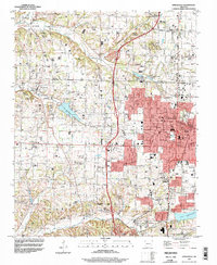
1994 Map of Springdale
USGS Topo · Published 1998About this map
The growing urban footprint of Springdale and Fayetteville dominates this mid-1990s survey, showing the intensification of development along the Benton Co and Washington Co line. The St Louis-San Francisco RR serves as a central north-south spine for the region, anchoring the industrial and residential corridors of Lowell, Bethel Heights, and Johnson. While the eastern half of the map shows dense street grids, including Emma Ave and Huntsville Ave, the western landscape retains a more open character defined by spring-fed waterways like Osage Creek and Brush Creek.
Find a feature on this map
62 named features on this map. Tap any name to fly to it.
Don’t see what you’re looking for? This feature index may not catch every label — zoom into the map to look around manually.
Map Details
Editions of this 1994 Springdale Map
This is the sole edition of this map. No revisions or reprints were ever made.
Other maps of this area

1899 · Fayetteville
USGS Topo · 1:125,000

1901 · Fayetteville
USGS Topo · 1:125,000

1904 · Fayetteville
USGS Topo · 1:125,000

1954 · Tulsa
USGS Topo · 1:250,000

1958 · Sonora
USGS Topo · 1:24,000

1958 · Rogers
USGS Topo · 1:24,000

1958 · Fayetteville
USGS Topo · 1:24,000

1958 · Elkins
USGS Topo · 1:24,000

1958 · Tulsa
USGS Topo · 1:250,000

1963 · Tulsa
USGS Topo · 1:250,000