1900s (20th Century) Maps of Colt, Arkansas
Explore 7 historic maps of Colt from the 1900s (20th Century). These maps offer a rare glimpse into what life looked like during the 1900s — showing old roads, neighborhoods, homes, and landmarks that have changed or disappeared over time.
Whether you're researching your family's past, planning a metal detecting trip, or studying how Colt's landscape evolved across the 1900s, these high-resolution maps are a powerful tool for exploring the history of this region.
- Focus on a specific era: All maps on this page are from the 1900s, giving you a focused view of this time period.
- See what’s changed: Compare century-old streets, trails, and buildings to today's modern landscape using overlays and satellite layers.
- Research with precision: Use these maps for genealogy, historical research, land use analysis, or educational projects.
- View, download, or print: Maps are fully viewable online in high resolution, and can be downloaded or printed for your own records.
Start exploring Colt's history through authentic maps from the 1900s. This is your window into the past.
Colt, AR maps
(7)- 1939 Map of Wynne, 1941 Print
 1939 Wynne1941 Print · USGSEastern Arkansas at the end of the thirties was a region defined by the L'Anguille River and a thriving network of small rail towns and rural parishes. Researchers can trace ancestral roots through dozens of local landmarks like Wick Mill, Smith Chapel, and Bible Union Sch.2 unique versions available
 - 1953 Map of Memphis, 1966 Print
 1953 Memphis1966 Print · USGSEastern Arkansas and the Memphis riverfront are shown here during the mid-century period of regional growth and river management. Local historians can trace the paths of the Chicago Rock Island & Pacific RR through Forrest City or locate river landmarks like President's Island.3 unique versions available
 - 1956 Map of Memphis
 1956 Memphis1956 Print · USGSThe Mississippi Delta and the bluffs of West Tennessee meet in the mid-fifties, showing a landscape defined by massive river systems and rail hubs. Researchers can trace the path of Crowleys Ridge or locate vanished river landings near Centennial Island and Island No 35.
 - 1958 Map of Wynne
 1958 Wynne1958 Print · USGSEastern Arkansas in the late fifties shows a landscape of vibrant rail towns and rural parishes between Wynne and Forrest City. Genealogists and historians can trace dozens of landmarks like Slonikers Mill, Cogbill Cem, and Hedge Providence Ch.2 unique versions available
 - 1958 Map of Forrest City, 1959 Print
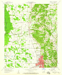 1958 Forrest City1959 Print · USGSForrest City stands at the foot of Crowleys Ridge in the late fifties, where major rail lines converge amidst a landscape of river bottoms and upland gravel pits. Genealogists can trace rural family roots through landmarks like Poplar Grove Cem, Hogan Chapel, and the Lincoln High Sch.2 unique versions available
 - 1984 Map of Wynne, 1985 Print
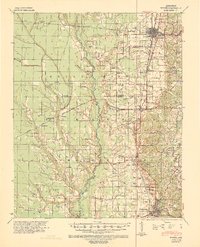
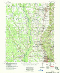
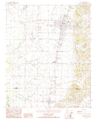 1984 Wynne1985 Print · USGSIn the early 1980s, the landscape around the city of Wynne was defined by the sharp rise of Crowleys Ridge above the delta. Genealogists and historians can trace small communities like McElroy, Colt, and Fitzgerald Crossing alongside the winding Lick Creek.2 unique versions available
 - 1986 Map of Memphis West
 1986 Memphis West1986 Print · USGSThe Mississippi River delta and the rise of Crowleys Ridge define this mid-1980s look at the Mid-South. Researchers can trace the development of West Memphis and Marion or locate landmarks like Crittenden Mem Cem and Village Creek State Park.2 unique versions available
End of results
Showing maps 1-7 of 7
Top cities near Colt
- Forrest City historical maps
- Wynne historical maps
- Madison historical maps
- Palestine historical maps
- Caldwell historical maps
- Widener historical maps
Frequently asked questions
- What are the different types of historical maps available for Colt?
- What is the oldest map of Colt?
- Where can I purchase historical maps of Colt for my home or office?
- Where can I download high-res historical maps of Colt?
- Are there historical topographic maps available for Colt?
- Is there historical aerial imagery available for Colt?
- Where are historical maps of Colt sourced from?