1930s Maps of Pigeon Hill, Arkansas
Explore 3 historic maps of Pigeon Hill from the 1930s. These maps offer a rare glimpse into what life looked like during the 1930s — showing old roads, neighborhoods, homes, and landmarks that have changed or disappeared over time.
Whether you're researching your family's past, planning a metal detecting trip, or studying how Pigeon Hill's landscape evolved across the 1930s, these high-resolution maps are a powerful tool for exploring the history of this region.
- Focus on a specific era: All maps on this page are from the 1930s, giving you a focused view of this time period.
- See what’s changed: Compare century-old streets, trails, and buildings to today's modern landscape using overlays and satellite layers.
- Research with precision: Use these maps for genealogy, historical research, land use analysis, or educational projects.
- View, download, or print: Maps are fully viewable online in high resolution, and can be downloaded or printed for your own records.
Start exploring Pigeon Hill's history through authentic maps from the 1930s. This is your window into the past.
Pigeon Hill, AR maps
(3)- 1934 Map of Moro Bay, 1960 Print
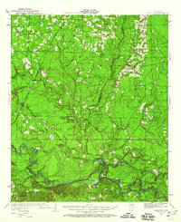 1934 Moro Bay1960 Print · USGSSouthern Arkansas at the height of the river-and-rail era is captured here, showing the intricate wetlands of the Ouachita valley. Researchers can locate old riverside hubs like Moro Bay, the tracks of the Chicago Rock Island and Pacific, and rural landmarks like Faustina Ch.
 - 1938 Map of Moro Bay
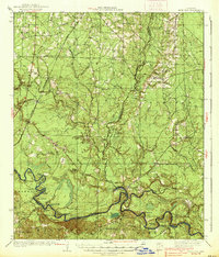 1938 Moro Bay1938 Print · USGSThe riverbottoms of the Ouachita and the timberlands of South Arkansas are captured here in the mid-1930s. Genealogists can locate family sites near Jersey Sch and Union Grove Ch, or trace old river traffic at Wilmington Landing.2 unique versions available
 - 1939 Map of Moro Bay, 1941 Print
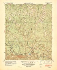 1939 Moro Bay1941 Print · USGSSouthern Arkansas was a land of river landings and remote timber camps in the late 1930s. Genealogists and local historians can trace the foundations of communities at Artesian and Moro Bay, or locate rural landmarks like Union Grove Ch and Beulah Springs Sch.2 unique versions available
End of results
Showing maps 1-3 of 3
Top cities near Pigeon Hill
- Huttig historical maps
- Strong historical maps
- Hermitage historical maps
- Calion historical maps
- Felsenthal historical maps
Frequently asked questions
- What are the different types of historical maps available for Pigeon Hill?
- What is the oldest map of Pigeon Hill?
- Where can I purchase historical maps of Pigeon Hill for my home or office?
- Where can I download high-res historical maps of Pigeon Hill?
- Are there historical topographic maps available for Pigeon Hill?
- Is there historical aerial imagery available for Pigeon Hill?
- Where are historical maps of Pigeon Hill sourced from?