1960s Maps of Andrews, Arkansas
Explore 2 historic maps of Andrews from the 1960s. These maps offer a rare glimpse into what life looked like during the 1960s — showing old roads, neighborhoods, homes, and landmarks that have changed or disappeared over time.
Whether you're researching your family's past, planning a metal detecting trip, or studying how Andrews's landscape evolved across the 1960s, these high-resolution maps are a powerful tool for exploring the history of this region.
- Focus on a specific era: All maps on this page are from the 1960s, giving you a focused view of this time period.
- See what’s changed: Compare century-old streets, trails, and buildings to today's modern landscape using overlays and satellite layers.
- Research with precision: Use these maps for genealogy, historical research, land use analysis, or educational projects.
- View, download, or print: Maps are fully viewable online in high resolution, and can be downloaded or printed for your own records.
Start exploring Andrews's history through authentic maps from the 1960s. This is your window into the past.
Andrews, AR maps
(2)- 1964 Map of West Point, 1965 Print
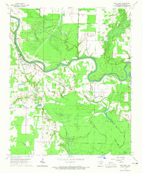 1964 West Point1965 Print · USGSWhite County, Arkansas, during the mid-sixties reveals a riverine landscape dominated by the Little Red River and its intricate wetlands. Genealogists and local historians can trace the foundations of West Point and find markers like New Hope Ch, Riverside Cem, and the Old Railroad Grade.2 unique versions available
 - 1967 Map of Kensett
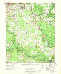 1967 Kensett1967 Print · USGSWhite County, Arkansas, comes to life in this mid-century survey as the regional rail network and the Little Red River shape the local economy. Researchers can locate family landmarks like Ellis Chapel, Liberty Cem, and the old Gravel Pits south of Searcy.
End of results
Showing maps 1-2 of 2
Top cities near Andrews
- Searcy historical maps
- Bald Knob historical maps
- Augusta historical maps
- Judsonia historical maps
- Des Arc historical maps
- Kensett historical maps
See more
Frequently asked questions
- What are the different types of historical maps available for Andrews?
- What is the oldest map of Andrews?
- Where can I purchase historical maps of Andrews for my home or office?
- Where can I download high-res historical maps of Andrews?
- Are there historical topographic maps available for Andrews?
- Is there historical aerial imagery available for Andrews?
- Where are historical maps of Andrews sourced from?