1930s Maps of Woodruff County, Arkansas
Explore 3 historic maps of Woodruff County from the 1930s. These maps offer a rare glimpse into what life looked like during the 1930s — showing old roads, neighborhoods, homes, and landmarks that have changed or disappeared over time.
Whether you're researching your family's past, planning a metal detecting trip, or studying how Woodruff County's landscape evolved across the 1930s, these high-resolution maps are a powerful tool for exploring the history of this region.
- Focus on a specific era: All maps on this page are from the 1930s, giving you a focused view of this time period.
- See what’s changed: Compare century-old streets, trails, and buildings to today's modern landscape using overlays and satellite layers.
- Research with precision: Use these maps for genealogy, historical research, land use analysis, or educational projects.
- View, download, or print: Maps are fully viewable online in high resolution, and can be downloaded or printed for your own records.
Start exploring Woodruff County's history through authentic maps from the 1930s. This is your window into the past.
Woodruff County, AR maps
(3)- 1935 Map of Augusta, 1938 Print
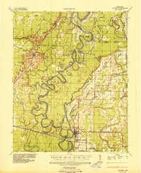 1935 Augusta1938 Print · USGSThe Arkansas Delta comes alive in the mid-1930s as the White River winds past the railroad hubs of Augusta and New Augusta. Genealogists can locate family landmarks like Spriggs Mill, Holly Grove Church, and various river landings including Hames Ferry.2 unique versions available
 - 1935 Map of Gregory, 1946 Print
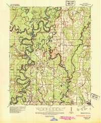 1935 Gregory1946 Print · USGSThe Arkansas Delta comes to life in the mid-1930s, showing a river-rich landscape of timber and rail commerce. Genealogists can trace family footprints through rural landmarks like Revel Cem, McClelland, and the riverfront at Georgetown.
 - 1939 Map of Hunter, 1942 Print
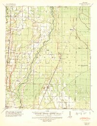 1939 Hunter1942 Print · USGSWoodruff and Cross counties were at the peak of their rail-driven economy just before the war, when timber and agriculture dominated the Delta. Genealogists can trace family names at Odd Fellows Cem or locate rural landmarks like Hillmann Jr High Sch and the Whitehall Ch & Cem.2 unique versions available
End of results
Showing maps 1-3 of 3
Top cities of Woodruff County
- Augusta historical maps
- McCrory historical maps
- Cotton Plant historical maps
- Patterson historical maps
- Hunter historical maps
Frequently asked questions
- What are the different types of historical maps available for Woodruff County?
- What is the oldest map of Woodruff County?
- Where can I purchase historical maps of Woodruff County for my home or office?
- Where can I download high-res historical maps of Woodruff County?
- Are there historical topographic maps available for Woodruff County?
- Is there historical aerial imagery available for Woodruff County?
- Where are historical maps of Woodruff County sourced from?