1980s Maps of Woodruff County, Arkansas
Explore 4 historic maps of Woodruff County from the 1980s. These maps offer a rare glimpse into what life looked like during the 1980s — showing old roads, neighborhoods, homes, and landmarks that have changed or disappeared over time.
Whether you're researching your family's past, planning a metal detecting trip, or studying how Woodruff County's landscape evolved across the 1980s, these high-resolution maps are a powerful tool for exploring the history of this region.
- Focus on a specific era: All maps on this page are from the 1980s, giving you a focused view of this time period.
- See what’s changed: Compare century-old streets, trails, and buildings to today's modern landscape using overlays and satellite layers.
- Research with precision: Use these maps for genealogy, historical research, land use analysis, or educational projects.
- View, download, or print: Maps are fully viewable online in high resolution, and can be downloaded or printed for your own records.
Start exploring Woodruff County's history through authentic maps from the 1980s. This is your window into the past.
Woodruff County, AR maps
(4)- 1980 Map of Tilton
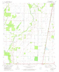 1980 Tilton1980 Print · USGSNear the Woodruff and Jackson county lines in the 1970s, this area shows a landscape of bayous and rail-side settlements. Genealogists and local historians can trace the rural communities of Pumpkin Bend and Tilton, or locate the Morton Cem and Betts Cem.
 - 1980 Map of Mc Crory
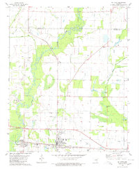 1980 Mc Crory1980 Print · USGSWoodruff County in the late seventies is captured here at the intersection of the Missouri Pacific rail line and the meandering Cache River. Genealogists and local historians can locate several rural landmarks including Fakes Chapel Cem, Morning View Ch, and the settlement of Overcup.
 - 1986 Map of Brinkley
 1986 Brinkley1986 Print · USGSThe Grand Prairie and White River basin come to life in the mid-1980s, showing the intersection of heavy rail and interstate travel through eastern Arkansas. Genealogists can locate family sites near Sylvania Cem, Oak Grove Ch, and the rural community of De Valls Bluff.
 - 1986 Map of Searcy
 1986 Searcy1986 Print · USGSWhite County and its neighbors reached a period of established agricultural and rail prosperity by the mid-1980s. Local researchers can trace the routes of the Missouri Pacific RR and locate rural communities like Velvet Ridge, Sunnydale, and Cotton Plant.2 unique versions available
End of results
Showing maps 1-4 of 4
Top cities of Woodruff County
- Augusta historical maps
- McCrory historical maps
- Cotton Plant historical maps
- Patterson historical maps
- Hunter historical maps
Frequently asked questions
- What are the different types of historical maps available for Woodruff County?
- What is the oldest map of Woodruff County?
- Where can I purchase historical maps of Woodruff County for my home or office?
- Where can I download high-res historical maps of Woodruff County?
- Are there historical topographic maps available for Woodruff County?
- Is there historical aerial imagery available for Woodruff County?
- Where are historical maps of Woodruff County sourced from?