Old Maps of Newark, California for Metal Detecting
Plan your next treasure hunt with 69 historic maps of Newark. Find old homesites, ghost towns, trails, and gathering spots that may be lost to time — perfect for identifying promising metal detecting locations.
- Locate forgotten sites: Uncover places like long-lost settlements, abandoned rail lines, or gathering spots.
- Plan better hunts: Use map overlays combined with LiDAR or satellite views to narrow in on historically rich areas.
- Made for detectorists: Thousands of hobbyists use these maps to discover relics, coins, and hidden history.
Use these historic maps to boost your research and find new opportunities beneath the surface of Newark.
Newark, CA maps
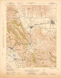
(69)- 1889 Map of San Jose, 1939 Print
 1889 San Jose1939 Print · USGSSanta Clara County during the late nineteenth century was a mosaic of historic ranchos and developing rail lines. Genealogists can trace family footprints through early settlements like Milpitas, Berryessa, and the grounds of the Santa Clara Co. Alms House.2 unique versions available
 - 1897 Map of San Jose
 1897 San Jose1897 Print · USGSThe Santa Clara Valley at the close of the nineteenth century is captured here as a landscape of vast ranchos and emerging rail towns. Genealogists can trace family lands across the Enright Tract or locate ancestors at the County Infirmary, Agnew, and Willow Glen.
 - 1897 Map of Palo Alto
 1897 Palo Alto1897 Print · USGSThe San Francisco Peninsula and Santa Clara Valley emerge in the late nineteenth century as academic and rail hubs. Trace the early footprints of Stanford University, the primary line of the Southern Pacific RR, and the transition of old ranchos like La Purisima Concepcion.
 - 1899 Map of San Jose
 1899 San Jose1899 Print · USGSThe Santa Clara Valley at the end of the century reveals a landscape of ranchos and growing rail hubs. Genealogists can trace family names and institutions from San Jose to the Santa Clara Co. Alms House and Agnew asylum.6 unique versions available
 - 1899 Map of Palo Alto
 1899 Palo Alto1899 Print · USGSThe San Francisco Peninsula was entering a period of rapid development in the 1890s as railroad towns began to flourish around the new Stanford University campus. You can trace early property lines across Pastoria de las Borregas or locate nineteenth-century landings like Cooley Landing and Jagel Landing.11 unique versions available
 - 1899 Map of Haywards
 1899 Haywards1899 Print · USGSThe East Bay shoreline at the end of the century was a landscape of industrial salt works and vital maritime landings. Genealogists and historians can trace the early rail stops at Haywards Sta. or locate family trade hubs at Mulford Landing and Jarvis Landing.5 unique versions available
 - 1902 Map of Santa Cruz
 1902 Santa Cruz1902 Print · USGSCoastal California at the end of the Victorian era reveals a landscape of redwood forests, early university towns, and remote Pacific outposts. Genealogists and historians can trace the early rail corridors through Boulder Creek and Felton or locate coastal landmarks like Pigeon Point and Halfmoon Bay.9 unique versions available
 - 1906 Map of Pleasanton
 1906 Pleasanton1906 Print · USGSThe Livermore and Amador Valleys are captured here at the turn of the century as they transitioned from ranch lands to thriving rail hubs. Genealogists and historians can trace family locations near Mission San Jose, the old Dougherty Post Office, and the junction at Niles.5 unique versions available
 - 1915 Map of Haywards
 1915 Haywards1915 Print · USGSThe East Bay shoreline and inland foothills are shown here in the mid-1910s during a height of coastal industry. Genealogists and historians can trace old shipping points like Mulford Landing, early salt operations at Union City Salt Works, and the rail lines of the Western Pacific.4 unique versions available
 - 1941 Map of Pleasanton
 1941 Pleasanton1941 Print · USGSThe Livermore Valley and East Bay hills are captured here in the early 1940s, showing a world of cattle ranchos and railroad towns. You can trace early landmarks like the Mission San Jose de Guadalupe, the Livermore Airport, and several rural one-room schoolhouses like Antone Sch.
 - 1941 Map of Palo Alto
 1941 Palo Alto1941 Print · USGSThe Peninsula and Santa Clara Valley are seen here in the early 1940s, just as the region began its mid-century transformation. Researchers can trace the layout of Stanford University, the military grounds of Moffett Field, and local landmarks like Flood Park.
 - 1942 Map of Hayward
 1942 Hayward1942 Print · USGSThe East Bay shoreline and inland foothills come alive in the early 1940s as industry and infrastructure reshape the landscape. Researchers can trace the original footprints of Russell City and Mt Eden or locate the historic Oakland Speedway and Fairmont Hospital.
 - 1943 Map of Palo Alto
 1943 Palo Alto1943 Print · USGSThe San Francisco Peninsula was still a region of orchards and academic outposts in the years following the Great Depression. Researchers can trace the development of early Silicon Valley through the Southern Pacific line and family landmarks like Duveneck Ranch and the Whisman Dist School.
 - 1943 Map of Pleasanton
 1943 Pleasanton1943 Print · USGSThe Livermore and Amador Valleys are captured during the early 1940s, showing a landscape of ranching, railroads, and early institutional development. Genealogists and historians can locate old schools like Stonybrook Sch and landmarks such as Mission San Jose de Guadalupe.
 - 1943 Map of San Jose
 1943 San Jose1943 Print · USGSThe Santa Clara Valley is seen here in the early 1940s, showing a landscape of orchards and rail junctions. Trace family roots in San Jose or locate old landmarks like the Agnew State Hospital and Oak Hill Memorial Park.
 - 1947 Map of San Francisco, 1948 Print
 1947 San Francisco1948 Print · USGSThe Bay Area in the late 1940s reveals a region transitioning from wartime intensity to post-war suburban growth. Trace the historic rail lines of the Southern Pacific RR or locate early military footprints at Fort Funston and Moffett Field.
 - 1947 Map of San Jose, 1948 Print
 1947 San Jose1948 Print · USGSNorthern California's heartland is captured here just after the war, showing the rapid growth of the Santa Clara and Central Valleys. Researchers can trace the legacy of rail and water at Castle Air Force Base, Stockton, and the Hetch Hetchy Aqueduct.
 - 1947 Map of Newark, 1958 Print
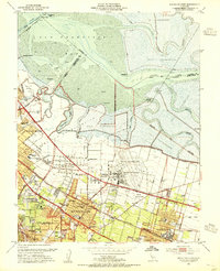
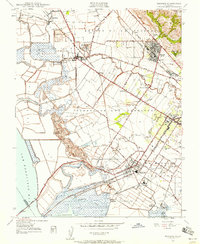 1947 Newark1958 Print · USGSThe industrial shoreline and agricultural plains of the East Bay are captured here just after the war. Local historians can trace early landings like Jarvis Landing and family landmarks such as Patterson Ranch and the Masonic Home.
 - 1948 Map of Newark
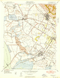 1948 Newark1948 Print · USGSCoastal Alameda County is captured here in the late 1940s, showing a landscape defined by salt refineries and historic ranching tracts. Researchers can trace the industrial roots of Alvarado and Newark or locate family-history sites like the Masonic Home and Cypress Cem.
 - 1948 Map of San Francisco, 1951 Print
 1948 San Francisco1951 Print · USGSThe Bay Area in the late 1940s reveals a landscape defined by rapid post-war growth and a heavy military presence at the Golden Gate. Trace the development of early trans-bay infrastructure like the Oakland-Bay Bridge and historic coastal defense sites such as Fort Funston and Alcatraz Island.
 - 1948 Map of Palo Alto, 1956 Print
 1948 Palo Alto1956 Print · USGSThe San Francisco Peninsula is captured here during its postwar transformation into a suburban and technological hub. Genealogists and local historians can trace early neighborhood boundaries near Stanford University, the sprawling Moffet Naval Air Station, and family landmarks like O'Neal Ranch.
 - 1953 Map of Milpitas, 1955 Print
 1953 Milpitas1955 Print · USGSThe South Bay marshlands and emerging suburban corridors of the early fifties are captured here before major development took hold. Researchers can trace the layout of Agnew State Hospital, the isolated rail stop at Drawbridge, and the historic Mission Santa Clara de Asis site.
 - 1953 Map of Mountain View, 1955 Print
 1953 Mountain View1955 Print · USGSThe South Bay shoreline and Peninsula communities are captured in the early fifties during a period of massive post-war growth. Researchers can trace the development of Mountain View and the expansive Moffett Field Naval Air Station alongside local landmarks like Castro City and Cooley Landing.2 unique versions available
 - 1953 Map of Niles, 1955 Print
 1953 Niles1955 Print · USGSCoastal foothills and rail towns define this East Bay landscape in the early fifties, before the surge of suburban development. Researchers can trace the layout of Mission San Jose, locate the Centerville Airport, and find early landmarks like the Water Temple or Ohlones Cemetery.
 - 1953 Map of San Jose, 1959 Print
 1953 San Jose1959 Print · USGSThe Santa Clara Valley comes alive in the mid-1950s, showing the transition from agricultural ranch lands to a growing suburban and industrial hub. Researchers can trace ancestral locations near Agnew State Hospital, the original village of Alviso, or the early campus of San Jose State College.
Showing maps 1-25 of 69
Top cities near Newark
- San Jose historical maps
- Oakland historical maps
- Fremont historical maps
- Hayward historical maps
- Sunnyvale historical maps
- Santa Clara historical maps
See more
Top neighborhoods of Newark
Frequently asked questions
- What are the different types of historical maps available for Newark?
- What is the oldest map of Newark?
- Where can I purchase historical maps of Newark for my home or office?
- Where can I download high-res historical maps of Newark?
- Are there historical topographic maps available for Newark?
- Is there historical aerial imagery available for Newark?
- Where are historical maps of Newark sourced from?