1950s Maps of Pleasanton, California
Explore 6 historic maps of Pleasanton from the 1950s. These maps offer a rare glimpse into what life looked like during the 1950s — showing old roads, neighborhoods, homes, and landmarks that have changed or disappeared over time.
Whether you're researching your family's past, planning a metal detecting trip, or studying how Pleasanton's landscape evolved across the 1950s, these high-resolution maps are a powerful tool for exploring the history of this region.
- Focus on a specific era: All maps on this page are from the 1950s, giving you a focused view of this time period.
- See what’s changed: Compare century-old streets, trails, and buildings to today's modern landscape using overlays and satellite layers.
- Research with precision: Use these maps for genealogy, historical research, land use analysis, or educational projects.
- View, download, or print: Maps are fully viewable online in high resolution, and can be downloaded or printed for your own records.
Start exploring Pleasanton's history through authentic maps from the 1950s. This is your window into the past.
Pleasanton, CA maps
(6)- 1953 Map of La Costa Valley, 1954 Print
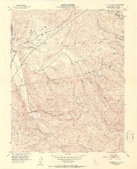 1953 La Costa Valley1954 Print · USGSCoastal range ridges and interior valleys of Alameda County are captured here in the mid-fifties. Researchers can trace the path of the Hetch Hetchy Aqueduct and locate local landmarks like Scotts Corner and the Arroyo Del Valle Sanatorium.3 unique versions available
 - 1953 Map of Livermore, 1954 Print
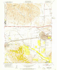 1953 Livermore1954 Print · USGSThe Livermore Valley was a landscape of military bases and rail-hubs in the early fifties. Genealogists and historians can trace the foundations of Livermore and Pleasanton near landmarks like the Livermore Sanitarium, Dow Airport, and St Michaels Cemetery.2 unique versions available
 - 1953 Map of Dublin, 1955 Print
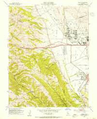 1953 Dublin1955 Print · USGSThe Amador and San Ramon Valleys are captured here during the post-war era, as military installations and suburban pockets began to transform the ranchlands. Local historians can trace the foundations of Parks Air Force Base, the Old Hearst Ranch, and the early layout of Pleasanton.2 unique versions available
 - 1953 Map of Niles, 1955 Print
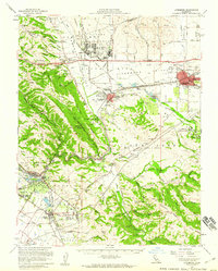
 1953 Niles1955 Print · USGSCoastal foothills and rail towns define this East Bay landscape in the early fifties, before the surge of suburban development. Researchers can trace the layout of Mission San Jose, locate the Centerville Airport, and find early landmarks like the Water Temple or Ohlones Cemetery.
 - 1953 Map of Livermore, 1960 Print
 1953 Livermore1960 Print · USGSThe East Bay valleys are shown during a period of significant growth and military activity in the early fifties. Researchers can trace historic family locations at Mission San Jose and local landmarks like the Water Temple or the Old Hearst Ranch.
 - 1956 Map of San Jose
 1956 San Jose1956 Print · USGSCentral California in the mid-fifties reveals the transition from sprawling orchards to growing urban hubs like San Jose and Stockton. Genealogists and historians can trace the rail-era landscape of the Mother Lode through Chinese Camp and Tuttletown, or follow the water through the Joaquin River and Calaveras Reservoir.
End of results
Showing maps 1-6 of 6
Top cities near Pleasanton
- San Jose historical maps
- Fremont historical maps
- Hayward historical maps
- Sunnyvale historical maps
- Livermore historical maps
- Milpitas historical maps
See more
Top neighborhoods of Pleasanton
- Hacienda historical maps
- Irby Ranch historical maps
- Del Prado historical maps
- Ruby Hill historical maps
- Shadow Cliffs historical maps
Frequently asked questions
- What are the different types of historical maps available for Pleasanton?
- What is the oldest map of Pleasanton?
- Where can I purchase historical maps of Pleasanton for my home or office?
- Where can I download high-res historical maps of Pleasanton?
- Are there historical topographic maps available for Pleasanton?
- Is there historical aerial imagery available for Pleasanton?
- Where are historical maps of Pleasanton sourced from?