1950s Maps of Cape Horn, California
Explore 2 historic maps of Cape Horn from the 1950s. These maps offer a rare glimpse into what life looked like during the 1950s — showing old roads, neighborhoods, homes, and landmarks that have changed or disappeared over time.
Whether you're researching your family's past, planning a metal detecting trip, or studying how Cape Horn's landscape evolved across the 1950s, these high-resolution maps are a powerful tool for exploring the history of this region.
- Focus on a specific era: All maps on this page are from the 1950s, giving you a focused view of this time period.
- See what’s changed: Compare century-old streets, trails, and buildings to today's modern landscape using overlays and satellite layers.
- Research with precision: Use these maps for genealogy, historical research, land use analysis, or educational projects.
- View, download, or print: Maps are fully viewable online in high resolution, and can be downloaded or printed for your own records.
Start exploring Cape Horn's history through authentic maps from the 1950s. This is your window into the past.
Cape Horn, CA maps
(2)- 1956 Map of Dardanelles Cone, 1959 Print
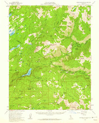 1956 Dardanelles Cone1959 Print · USGSThe High Sierra of Tuolumne and Alpine counties appears here in the mid-fifties, during a peak era of summer camp expansion and reservoir development. Researchers can trace the layout of early recreation sites like the Douglas Resort, Sierra Girl Scout Camp, and Dardanelle PO.3 unique versions available
 - 1957 Map of Walker Lake
 1957 Walker Lake1957 Print · USGSThe Nevada-California borderlands in the mid-1950s show a rugged network of mining camps and river-valley towns centered around Walker Lake. Researchers can trace the Southern Pacific rail line and locate historical sites like Bodie, Sodaville, and the Leviathan Sulphur Mine.4 unique versions available
End of results
Showing maps 1-2 of 2
Top cities near Cape Horn
Frequently asked questions
- What are the different types of historical maps available for Cape Horn?
- What is the oldest map of Cape Horn?
- Where can I purchase historical maps of Cape Horn for my home or office?
- Where can I download high-res historical maps of Cape Horn?
- Are there historical topographic maps available for Cape Horn?
- Is there historical aerial imagery available for Cape Horn?
- Where are historical maps of Cape Horn sourced from?