Old Maps of Nelson, Durham for Academic Research
Study the evolution of Nelson with 14 high-resolution historic maps. Whether you're teaching, researching, or modeling changes in land use, these maps provide essential visual documentation of urban, environmental, and geographic change.
- Analyze long-term change: Track patterns in development, transportation, and natural features.
- Ideal for environmental or urban studies: Support academic projects with primary historical map data.
- Use in the classroom or lab: Educators and researchers rely on these maps to bring historical context to life.
These maps are a powerful tool for teaching, research, and visualizing how Nelson has changed over the decades.
Nelson, Durham maps
(14)- 1891 Map of Chico
 1891 Chico1891 Print · USGSUpper Sacramento Valley life in the late nineteenth century revolved around the rail lines and river landings of Chico and Oroville. Genealogists and researchers can trace the early layout of mountain settlements like Magalia and Nimshew or locate old industrial sites including Keefers Old Mill and Doons Mill.
 - 1893 Map of Chico
 1893 Chico1893 Print · USGSNorthern California at the height of the nineteenth-century rail and ranching era reveals a network of valley landings and mountain mining camps. Genealogists and historians can trace family locations from Chico to remote spots like Helltown, Old Lovelock, and the Lucretia Mine.
 - 1895 Map of Chico
 1895 Chico1895 Print · USGSNorthern California at the close of the nineteenth century reveals a landscape defined by the Southern Pacific R. R. and early foothill industry. Trace the locations of historic lumber and mining operations like Keefer's Mill, Lucky Jim Mine, and Chapman's Mill.8 unique versions available
 - 1912 Map of Nelson
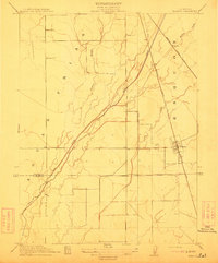 1912 Nelson1912 Print · USGSThe Central Valley's agricultural and rail-driven landscape comes into focus in the years before the Great War. Researchers can trace the diverging paths of the Southern Pacific RR and Northern Electric RR through Nelson and Esquon.2 unique versions available
 - 1948 Map of Nelson, 1957 Print
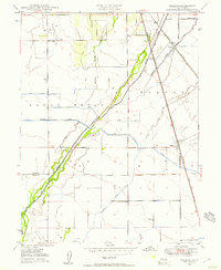 1948 Nelson1957 Print · USGSThe Sacramento Valley's agricultural heartland is captured here in the late 1940s, showing a landscape defined by irrigation and rail. Genealogists and historians can trace the rail sidings at Nelson and Esquon or the complex water network of the Western Canal and Butte Creek.4 unique versions available
 - 1949 Map of Chico, 1953 Print
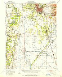 1949 Chico1953 Print · USGSMid-century Butte County thrives along the river and rail, from the academic center of Chico to the agricultural hubs of Durham and Nelson. Genealogists and researchers can trace local landmarks like Chico Cem, the Match Factory, and the Sacramento Northern railroad.3 unique versions available
 - 1950 Map of Nelson
 1950 Nelson1950 Print · USGSThe northern Sacramento Valley in the mid-century shows a landscape shaped by water engineering and dual rail lines. Researchers can trace the layout of the settlement at Nelson and follow the routes of the Southern Pacific and Western Pacific railroads.
 - 1958 Map of Chico, 1962 Print
 1958 Chico1962 Print · USGSMid-century Northern California comes to life across the Central Valley and high Sierras as the postwar economy transformed the landscape. Trace the rail lines of the Southern Pacific RR, locate family roots near Chico Cem, or explore the early layout of Paradise and Beale Air Force Base.4 unique versions available
 - 1960 Map of Chico
 1960 Chico1960 Print · USGSThe Northern California high country and Sacramento Valley meet in this 1960s-era landscape of mining towns and river settlements. Trace the rail-and-water economy of the gold country through the Empire Mine, Beale Air Force Base, and the Western Pacific Railroad.
 - 1980 Map of Chico
 1980 Chico1980 Print · USGSButte County and the Sierra foothills are shown here in the 1980s as the region's water and timber economies matured. Genealogists and researchers can trace old land grants like Rancho Capay or locate mountain mining sites and settlements such as Cherokee, Magalia, and the Big Bend Mine.2 unique versions available
 - 2012 Map of Nelson, 2012 Print
 2012 Nelson2012 Print · USGSCovers Nelson, including Durham, Esquon, and other nearby areas
 - 2015 Map of Nelson, 2015 Print
 2015 Nelson2015 Print · USGSCovers Nelson, including Durham, Esquon, and other nearby areas
 - 2018 Map of Nelson, 2018 Print
 2018 Nelson2018 Print · USGSCovers Nelson, including Durham, Esquon, and other nearby areas
 - 2021 Map of Nelson, 2021 Print
 2021 Nelson2021 Print · USGSButte County agriculture and water management are on full display in this early twenty-first-century survey of the Sacramento Valley. Genealogists and local historians can trace the community of Nelson, locate the Nelson Cem, and follow the path of the Western Canal through the valley floor.
End of results
Showing maps 1-14 of 14
Top cities near Nelson
- Chico historical maps
- Oroville historical maps
- Gridley historical maps
- Durham historical maps
- Paradise historical maps
- Biggs historical maps
See more
Frequently asked questions
- What are the different types of historical maps available for Nelson?
- What is the oldest map of Nelson?
- Where can I purchase historical maps of Nelson for my home or office?
- Where can I download high-res historical maps of Nelson?
- Are there historical topographic maps available for Nelson?
- Is there historical aerial imagery available for Nelson?
- Where are historical maps of Nelson sourced from?