1980s Maps of San Francisco, California
Explore 3 historic maps of San Francisco from the 1980s. These maps offer a rare glimpse into what life looked like during the 1980s — showing old roads, neighborhoods, homes, and landmarks that have changed or disappeared over time.
Whether you're researching your family's past, planning a metal detecting trip, or studying how San Francisco's landscape evolved across the 1980s, these high-resolution maps are a powerful tool for exploring the history of this region.
- Focus on a specific era: All maps on this page are from the 1980s, giving you a focused view of this time period.
- See what’s changed: Compare century-old streets, trails, and buildings to today's modern landscape using overlays and satellite layers.
- Research with precision: Use these maps for genealogy, historical research, land use analysis, or educational projects.
- View, download, or print: Maps are fully viewable online in high resolution, and can be downloaded or printed for your own records.
Start exploring San Francisco's history through authentic maps from the 1980s. This is your window into the past.
San Francisco, CA maps
(3)- 1985 Map of Farallon Islands
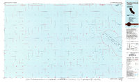 1985 Farallon Islands1985 Print · USGSThe Farallon Islands and their surrounding waters are captured in detail during the mid-eighties, highlighting the remote maritime geography of San Francisco. Trace the boundaries of the Farallon National Wildlife Refuge and locate landmarks like Southeast Farallon and Noonday Rock.
 - 1985 Map of San Francisco, 1989 Print
 1985 San Francisco1989 Print · USGSThe Bay Area is captured in the mid-1980s through experimental Landsat satellite imagery, offering a unique technological perspective of the California coast. Trace the urban boundaries of San Francisco and Alameda against the San Francisco Bay and Lorenzo.
 - 1988 Map of Farallon Islands
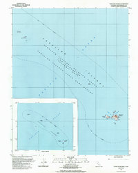 1988 Farallon Islands1988 Print · USGSThe isolated outcroppings of the Farallon Islands are shown in great detail during the late 1980s, documenting the vital maritime and wildlife protections in place. Researchers and maritime historians can locate specific island infrastructure like the Radio Tower and Derrick or trace the coastline of Fisherman Bay.
End of results
Showing maps 1-3 of 3
Top cities near San Francisco
- San Rafael historical maps
- Pacifica historical maps
- Mill Valley historical maps
- San Anselmo historical maps
- Larkspur historical maps
- Corte Madera historical maps
See more
Top neighborhoods of San Francisco
- Bayview District historical maps
- Mission District historical maps
- Western Addition historical maps
- South of Market historical maps
- Sunset District historical maps
- Richmond District historical maps
See more
Frequently asked questions
- What are the different types of historical maps available for San Francisco?
- What is the oldest map of San Francisco?
- Where can I purchase historical maps of San Francisco for my home or office?
- Where can I download high-res historical maps of San Francisco?
- Are there historical topographic maps available for San Francisco?
- Is there historical aerial imagery available for San Francisco?
- Where are historical maps of San Francisco sourced from?