1960s Maps of Contra Costa County, California
Explore 11 historic maps of Contra Costa County from the 1960s. These maps offer a rare glimpse into what life looked like during the 1960s — showing old roads, neighborhoods, homes, and landmarks that have changed or disappeared over time.
Whether you're researching your family's past, planning a metal detecting trip, or studying how Contra Costa County's landscape evolved across the 1960s, these high-resolution maps are a powerful tool for exploring the history of this region.
- Focus on a specific era: All maps on this page are from the 1960s, giving you a focused view of this time period.
- See what’s changed: Compare century-old streets, trails, and buildings to today's modern landscape using overlays and satellite layers.
- Research with precision: Use these maps for genealogy, historical research, land use analysis, or educational projects.
- View, download, or print: Maps are fully viewable online in high resolution, and can be downloaded or printed for your own records.
Start exploring Contra Costa County's history through authentic maps from the 1960s. This is your window into the past.
Contra Costa County, CA maps
(11)- 1960 Map of San Francisco
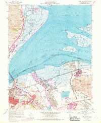
 1960 San Francisco1960 Print · USGSThe San Francisco Bay Area at the start of the sixties reveals a landscape of rapid expansion and critical infrastructure. Researchers can trace the development of East Bay communities like Russell City and Mt Eden or locate early rural landmarks like Alpine School.
 - 1961 Map of Dublin
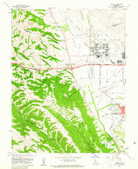 1961 Dublin1961 Print · USGSThe San Ramon Valley and surrounding ridges appear here in the early sixties, a time when massive military installations and ranching still defined the landscape. You can trace the footprint of Camp Parks and find local landmarks like Murray Sch and the community of Komandorski Village.10 unique versions available
 - 1961 Map of Livermore
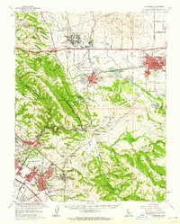
 1961 Livermore1961 Print · USGSLivermore and Pleasanton were expanding rapidly in the early sixties as the agricultural Amador Valley began to modernize. Genealogists and local historians can trace the foundations of the community through the Masonic Cem, old school sites like Inman Sch, and the Southern Pacific rail lines.6 unique versions available
 - 1961 Map of San Francisco
 1961 San Francisco1961 Print · USGSThe Bay Area at the dawn of the 1960s reveals a landscape of growing cities and massive Cold War military installations. Genealogists and historians can trace the mid-century urban footprint from Berkeley to San Mateo, while locating landmarks like the Presidio, Alcatraz Island, and Moffett Field Air Station.
 - 1961 Map of Livermore, 1962 Print
 1961 Livermore1962 Print · USGSThe Amador and Livermore Valleys appear here during a period of significant institutional and suburban growth in the early sixties. Genealogists and local historians can trace the districts of Fremont and find landmarks like St Mary of the Palms or Camp Parks.2 unique versions available
 - 1962 Map of San Jose
 1962 San Jose1962 Print · USGSCentral California in the early sixties showcases the expansion of the San Joaquin and Santa Clara valleys. Researchers can trace the rail-to-road transition along the Southern Pacific RR or locate landmarks like Castle USAF Base and Loma Prieta.4 unique versions available
 - 1962 Map of Santa Rosa
 1962 Santa Rosa1962 Print · USGSThe North Bay and Wine Country were entering a period of significant growth in the early sixties, anchored by established rail corridors and coastal maritime commerce. Genealogists and historians can trace the development of Santa Rosa, locate the Mare Island Naval Shipyard, and follow the Northwestern Pacific RR through the Cotati Valley.
 - 1964 Map of Santa Rosa
 1964 Santa Rosa1964 Print · USGSThe North Bay and Wine Country appear in the mid-fifties during a period of significant military and educational growth. Trace old rail lines like the Northwestern Pacific RR and explore historic sites from Petaluma to the Benicia Arsenal.
 - 1964 Map of San Francisco
 1964 San Francisco1964 Print · USGSThe Bay Area in the mid-sixties shows a region of rapid suburban expansion and major military installations. Researchers can trace the development of the South Bay near Stanford University or locate family plots in the historic Cypress Lawn Cem and Holy Cross Cem.
 - 1966 Map of San Jose
 1966 San Jose1966 Print · USGSCentral California in the mid-1960s reveals a landscape of massive irrigation projects and expanding Cold War military footprints. Researchers can trace the rail-and-river network of the San Joaquin Valley or locate specialized sites like Castle Air Force Base and the Sharp General Depot (Military).
 - 1968 Map of Port Chicago, 1969 Print
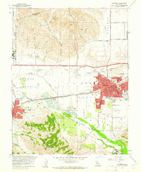
 1968 Port Chicago1969 Print · USGSContra Costa County at the end of the sixties shows a landscape of heavy industry and naval operations along the Suisun Bay waterfront. Genealogists and historians can trace the streets of Port Chicago, the grounds of the Naval Reservation, and local landmarks like the IOOF Cemetery.
End of results
Showing maps 1-11 of 11
Top cities of Contra Costa County
- Concord historical maps
- Antioch historical maps
- Richmond historical maps
- San Ramon historical maps
- Pittsburg historical maps
- Walnut Creek historical maps
See more
Frequently asked questions
- What are the different types of historical maps available for Contra Costa County?
- What is the oldest map of Contra Costa County?
- Where can I purchase historical maps of Contra Costa County for my home or office?
- Where can I download high-res historical maps of Contra Costa County?
- Are there historical topographic maps available for Contra Costa County?
- Is there historical aerial imagery available for Contra Costa County?
- Where are historical maps of Contra Costa County sourced from?