1970s Maps of Contra Costa County, California
Explore 8 historic maps of Contra Costa County from the 1970s. These maps offer a rare glimpse into what life looked like during the 1970s — showing old roads, neighborhoods, homes, and landmarks that have changed or disappeared over time.
Whether you're researching your family's past, planning a metal detecting trip, or studying how Contra Costa County's landscape evolved across the 1970s, these high-resolution maps are a powerful tool for exploring the history of this region.
- Focus on a specific era: All maps on this page are from the 1970s, giving you a focused view of this time period.
- See what’s changed: Compare century-old streets, trails, and buildings to today's modern landscape using overlays and satellite layers.
- Research with precision: Use these maps for genealogy, historical research, land use analysis, or educational projects.
- View, download, or print: Maps are fully viewable online in high resolution, and can be downloaded or printed for your own records.
Start exploring Contra Costa County's history through authentic maps from the 1970s. This is your window into the past.
Contra Costa County, CA maps
(8)- 1971 Map of San Francisco
 1971 San Francisco1971 Print · USGSThe San Francisco Bay Area at the start of the 1970s is shown here as a dense network of aerospace hubs, naval bases, and expanding suburbs. Researchers can trace the mid-century footprint of Stanford University, the industrial Salt Evaporators, and the Southern Pacific rail lines.
 - 1978 Map of Bouldin Island
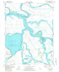 1978 Bouldin Island1978 Print · USGSThe California Delta was a labyrinth of waterways and reclaimed island tracts in the late 1970s. Trace the reach of the Deep Water Channel or locate specific points like Prisoners Point, the Venice Ferry, and Bethel Island.2 unique versions available
 - 1978 Map of Brentwood
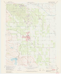 1978 Brentwood1978 Print · USGSBrentwood and the surrounding Delta-adjacent farm country are shown in the late seventies as the region balanced its agricultural roots with growing infrastructure. Researchers can trace family-named schools like Edna Hill Sch and Garin Sch alongside the path of the Mokelumne Aqueduct.3 unique versions available
 - 1978 Map of Jersey Island
 1978 Jersey Island1978 Print · USGSThe Sacramento-San Joaquin River Delta is captured here in the late seventies, a labyrinth of agricultural tracts and industrial gas fields. Genealogists and local historians can trace the development of Bethel Island, the rail corridor at Bridgehead, and the riverside settlement of Emmaton.
 - 1978 Map of Clifton Court Forebay
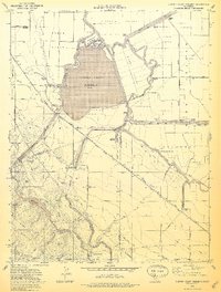 1978 Clifton Court Forebay1978 Print · USGSThe Sacramento-San Joaquin River Delta landscape of the late seventies was defined by a massive intersection of industrial water infrastructure and rural farmland. Researchers can trace the routes of the California Aqueduct, the community at Mountain House, and the namesake Clifton Court Forebay.3 unique versions available
 - 1978 Map of Antioch North
 1978 Antioch North1978 Print · USGSIn the late seventies, the Delta industrial corridor was a thriving hub of shipping, rail, and manufacturing. Trace the development of Antioch and Pittsburg alongside the historic Steel Mill and the secluded marshes of Sherman Island.4 unique versions available
 - 1978 Map of Woodward Island, 1979 Print
 1978 Woodward Island1979 Print · USGSThe California Delta in the late seventies is shown as a complex grid of reclaimed islands and sloughs. Trace the path of the Woodward Island Ferry and old rail stops like Orwood and Werner along the Mokelumne Aqueduct.2 unique versions available
 - 1978 Map of San Francisco, 1979 Print
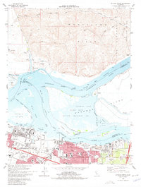
 1978 San Francisco1979 Print · USGSThe San Francisco Bay Area in the late seventies reveals a landscape where massive naval installations and federal parklands meet a rapidly maturing urban core. Genealogists and historians can locate family landmarks near the National Cemetery, trace the Southern Pacific rail lines, or study the layout of the Alameda Naval Air Station.2 unique versions available
End of results
Showing maps 1-8 of 8
Top cities of Contra Costa County
- Concord historical maps
- Antioch historical maps
- Richmond historical maps
- San Ramon historical maps
- Pittsburg historical maps
- Walnut Creek historical maps
See more
Frequently asked questions
- What are the different types of historical maps available for Contra Costa County?
- What is the oldest map of Contra Costa County?
- Where can I purchase historical maps of Contra Costa County for my home or office?
- Where can I download high-res historical maps of Contra Costa County?
- Are there historical topographic maps available for Contra Costa County?
- Is there historical aerial imagery available for Contra Costa County?
- Where are historical maps of Contra Costa County sourced from?