1910s Maps of Contra Costa County, California
Explore 15 historic maps of Contra Costa County from the 1910s. These maps offer a rare glimpse into what life looked like during the 1910s — showing old roads, neighborhoods, homes, and landmarks that have changed or disappeared over time.
Whether you're researching your family's past, planning a metal detecting trip, or studying how Contra Costa County's landscape evolved across the 1910s, these high-resolution maps are a powerful tool for exploring the history of this region.
- Focus on a specific era: All maps on this page are from the 1910s, giving you a focused view of this time period.
- See what’s changed: Compare century-old streets, trails, and buildings to today's modern landscape using overlays and satellite layers.
- Research with precision: Use these maps for genealogy, historical research, land use analysis, or educational projects.
- View, download, or print: Maps are fully viewable online in high resolution, and can be downloaded or printed for your own records.
Start exploring Contra Costa County's history through authentic maps from the 1910s. This is your window into the past.
Contra Costa County, CA maps
(15)- 1910 Map of Bouldin
 1910 Bouldin1910 Print · USGSThe Sacramento-San Joaquin Delta at the turn of the century is a labyrinth of reclaimed island tracts and sloughs. Trace the early river landings at Central Landing and Blakes Landing, or locate the Old Cannery along the South Fork Mokelumne River.3 unique versions available
 - 1910 Map of Jersey
 1910 Jersey1910 Print · USGSThe California Delta at the start of the century was a landscape of river-bound islands and vital steamboat landings. Genealogists and historians can trace old waterfront sites like Larsen Landing and Jersey, or the rail path of the A T and S F R R.3 unique versions available
 - 1911 Map of Byron Hot Springs
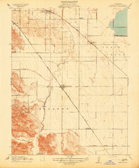
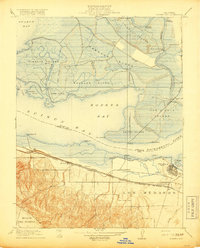
 1911 Byron Hot Springs1911 Print · USGSContra Costa County at the beginning of the twentieth century shows a landscape transitioning from ranching to railroad-driven tourism. Historians can trace the footprint of the Byron Hot Springs resort and the early rail infrastructure serving Byron.
 - 1913 Map of Woodward Island
 1913 Woodward Island1913 Print · USGSThe reclaimed islands of the California Delta appear in this pre-war survey as a sophisticated network of levees and rail. Trace early commercial hubs like the Cannery at Woodward and the rural Middle River Moorland P O.
 - 1914 Map of Brentwood
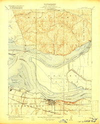
 1914 Brentwood1914 Print · USGSBrentwood and the surrounding orchards thrived in the early twentieth century as a dual-railroad crossroads. Researchers can trace early rural life through the Iron House School, the Southern Pacific RR tracks, and the Oil Pumping Station.
 - 1914 Map of Bethany
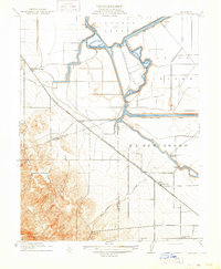 1914 Bethany1914 Print · USGSThe San Joaquin Delta was a maze of engineered waterways and rail lines just before the First World War. Researchers can trace the original routes of the Bethany Ferry and locate early landmarks like Mountain House and the Lammersville School.2 unique versions available
 - 1915 Map of Haywards
 1915 Haywards1915 Print · USGSThe East Bay shoreline and inland foothills are shown here in the mid-1910s during a height of coastal industry. Genealogists and historians can trace old shipping points like Mulford Landing, early salt operations at Union City Salt Works, and the rail lines of the Western Pacific.4 unique versions available
 - 1915 Map of Concord
 1915 Concord1915 Print · USGSContra Costa and Alameda counties are shown here just before the mid-century population boom, when the East Bay was a landscape of ranchos and rail stops. Genealogists can trace family footprints in small 1910s settlements like Moraga, Pacheco, and Lafayette.5 unique versions available
 - 1915 Map of San Francisco
 1915 San Francisco1915 Print · USGSSan Francisco and the East Bay appear at a pivotal moment just before the First World War, featuring the grand layout of the Panama-Pacific International Exposition. Genealogists and historians can trace the early rail networks of the Key Route Pier, the industrial waterfront at Winehaven, and historic landmarks like Cliff House.6 unique versions available
 - 1916 Map of Lone Tree Valley
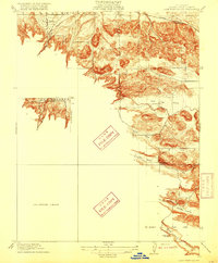 1916 Lone Tree Valley1916 Print · USGSContra Costa County at the onset of the motor age reveals a landscape of ranching valleys and early energy infrastructure. Researchers can trace the routes of Sand Creek and Marsh Creek, locate the isolated Deer Valley School, and see the early Oil Tanks in Markley Canyon.2 unique versions available
 - 1916 Map of Mare Island
 1916 Mare Island1916 Print · USGSThe northern San Pablo Bay region comes alive in this survey, showcasing a landscape of tidal marshes and rail-driven growth during the mid-1910s. Researchers can trace the layout of the Mare Island Navy Yard, the remote rail stop at Wingo, and the rural classrooms of Fly School.4 unique versions available
 - 1916 Map of Byron Hot Springs
 1916 Byron Hot Springs1916 Print · USGSEastern Contra Costa County was a landscape of historic land grants and early rail travel in the years before the Great War. Researchers can trace the original Southern Pacific route serving Byron and the specialized resort grounds of Byron Hot Springs.2 unique versions available
 - 1916 Map of Byron
 1916 Byron1916 Print · USGSIn the early twentieth century, the Contra Costa and San Joaquin borderlands were a landscape of reclaimed delta tracts and rising hill country. Researchers can trace early railroad alignments and rural life at Byron Hot Sprs, the Bethany Ferry, and the Vasco School.3 unique versions available
 - 1918 Map of Honker Bay
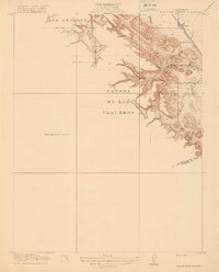
 1918 Honker Bay1918 Print · USGSThe industrial waterfront of Contra Costa and Solano counties comes alive in this survey of the Sacramento River delta. Trace the rail networks at Pittsburg and find historic riverfront stops like Birds Landing and Yolo Landing.2 unique versions available
 - 1918 Map of Collinsville
 1918 Collinsville1918 Print · USGSThe California Delta at the turn of the century shows a bustling junction of river and rail commerce. Researchers can trace early infrastructure around Antioch, locate riverfront sites like Montezuma Landing, and follow the Southern Pacific through the Los Medanos area.2 unique versions available
End of results
Showing maps 1-15 of 15
Top cities of Contra Costa County
- Concord historical maps
- Antioch historical maps
- Richmond historical maps
- San Ramon historical maps
- Pittsburg historical maps
- Walnut Creek historical maps
See more
Frequently asked questions
- What are the different types of historical maps available for Contra Costa County?
- What is the oldest map of Contra Costa County?
- Where can I purchase historical maps of Contra Costa County for my home or office?
- Where can I download high-res historical maps of Contra Costa County?
- Are there historical topographic maps available for Contra Costa County?
- Is there historical aerial imagery available for Contra Costa County?
- Where are historical maps of Contra Costa County sourced from?